Skip to content

Search Term Record

Metadata

Related Records

  1. Blueprint - 1984.021c.0007

    Map - Damon Mound Oil Field

    Record Type: Archive

    1984.021c.0007   Title Block
  2. Blueprint - 1988.070c.0155

    Map - J.J. Johnson property in Zeno Phillips league

    Record Type: Archive

    1988.070c.0155  Title Block
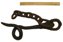
  3. Chain, Log - 1983.001c.0008

    Logging chains, used on San Bernard and Brazos Rivers (3 of them marked a,b,c) b&c marked

    Record Type: Object

    Logging chains
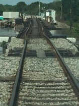
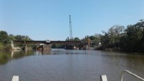
  4. Digital Image - 2017.010p.0013

    Union Pacific Railroad (UPRR) bridge damage after Hurricane Harvey. Photo taken September 2017 at San Bernard River bridge.

    Record Type: Photo

    2017.010p.0013
  5. Digital Image - 2017.010p.0014

    Union Pacific Railroad (UPRR) bridge under repairs after Hurricane Harvey, September 2017. Picture is of San Bernard River swing bridge

    Record Type: Photo

    2017.010p.0014
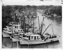
  6. Digital Image - 2017.010p.0015

    Dozens of shrimp boats massed together in the San Bernard River to protect them from Hurricane Beulah. Chronicle photo dated Thursday Sept 21, 1967. Caption on back reads: "Freeport shrimp fleet flees up San Bernard River for protection. Boats massed together at Brazoria 15 miles inland from Texas coast." Names of boats include "Big Daddy," "Regina Kate," "Helen Kay," "Mr. Tucker," "Starkist," and "My Doll."

    Record Type: Photo

    2017.010p.0015
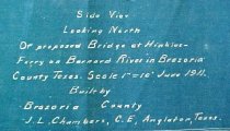
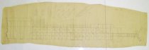
  7. Drawing - 1988.070c.0160

    Engineering Drawing - South Elevation of former Hinckles Ferry Bridge

    Record Type: Archive

    1988.070c.0160  Title Block
  8. Map - 1984.020c.0001

    Map - South Third of Brazoria County

    Record Type: Archive

    1984.020c.0001  Title Block
  9. Map - 1984.020c.0002

    Map - Middle Third of Brazoria County

    Record Type: Archive

    1984.020c.0002  Title Block
  10. Map - 1988.070c.0014

    Study Map for 1988.070c.0209

    Record Type: Archive

    Survey Map - Entire image
  11. Map - 1988.070c.0034

    Map - Prater and McNeil Leagues

    Record Type: Archive

    Map - Prater and McNeil Leagues
  12. Map - 1988.070c.0055

    Map - John & Sterling McNeel Leagues

    Record Type: Archive

    1988.070c.0055  Entire map
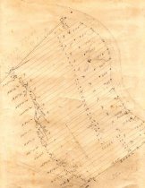
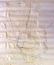
  13. Map - 1988.070c.0061

    Map - property divisions on west side of San Bernard River just south of the north line of T. H. Bell League.

    Record Type: Archive

    1988.070c.0061
  14. Map - 1988.070c.0070

    Map - Parker Williams Survey; Rebeca Murry Survey

    Record Type: Archive

    1988.070c.0070
  15. Map - 1988.070c.0073

    Map - Hunter Tract out of Austin 7 1/3 league

    Record Type: Archive

    1988.070c.0073  Title Block
  16. Map - 1988.070c.0078

    Map - Subdivision of J. A. Rhodes Estate

    Record Type: Archive

    1988.070c.0078  Title Block
  17. Map - 1988.070c.0081

    Map - South Texas Development Co. in Zeno Phillips League

    Record Type: Archive

    1988.070c.0018  Entire Map
  18. Map - 1988.070c.0089

    Map - Hunter Tract out of Austin 7 1/3 league

    Record Type: Archive

    1988.070c.0089  Title Block
  19. Map - 1988.070c.0108

    Map - Hinkle's Ferry and Vicinity in T.B.Bell League

    Record Type: Archive

    Map - Hinkle's Ferry and Vicinity in T.B.Bell League
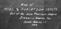
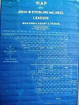
  20. Map - 1988.070c.0123

    Map - Hogg and Robertson Tracts out of Jesse Thompson League

    Record Type: Archive

    1988.070c.0123  Title Block

Thank You!

Confirmation Message Here....