
Archive Record
Images
Metadata
Object Name |
Map |
Catalog Number |
1988.070c.0078 |
Title |
Map - Subdivision of J. A. Rhodes Estate |
Search Terms |
Blueprint Columbia Road County Road 4 Hensley League James Hensley League Map Martin League Mound Creek San Bernard River South Texas Development Company Varner Creek Wiley Martin League |
Scope & Content |
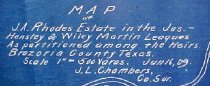
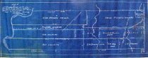
Map Cyanotype Blueprint of 1988.070c.0210 ---------------------------------------------------------------------------------------- Map of J. A. Rhodes Estate in the Jas. Hensley and Wiley Martin leagues as partitioned among the heirs, Brazoria County, Texas. Scale 1" = 500 varas. June 16, 1909. J. L. Chambers, County Surveyor. ---------------------------------------------------------------------------------------- North arrow: yes North direction: upper right corner of map Compass bearings: yes (just one, along Columbia Road) Scale: 1" = 500 varas Scale unit: vara Prominent features: - Columbia Road (now County Road 4) - Mound Creek - San Bernard River - Varner Creek Property owners: - Damon, S.W. - Rau. F.H. - Rhodes, Allen - Rhodes, Harry - Rhodes, J.H. - Rounds - Smith & Borden - South Texas Development Company - Yale |
Subjects |
Blueprint Columbia Road County Road 4 Hensley League James Hensley League Map Martin League Mound Creek San Bernard River South Texas Development Company Varner Creek Wiley Martin League |
People |
Bass, Nan Cannon Chambers, J. Lee Damon, S.W. Hensley, James Martin, Wiley Nash Rhodes, Allen Rhodes, Harry Rhodes, J.H. Rounds Smith Borden Yale |
Date |
06/16/09 |
Dates of Creation |
06/16/09 |
Extent of Description |
Paper: 20.5" wide x 8" high Image: 19" wide x 7" high |
Collection |
Nan Bass |
Accession number |
1988.070c |
Other number |
1988-70-78 |
Source |
Nan Bass |
Credit line |
Nan Bass |
Lexicon category |
8: Communication Artifact |
Catalog date |
1909-01-01 |
Catalog type |
Map |
Condition |
Fair |
Imagefile |
007\1988.070c.0078-1.JPG |
Number of images |
2 |
Relation |
Show Related Records... |