
Archive Record
Images
Metadata
Object Name |
Map |
Catalog Number |
1988.070c.0070 |
Title |
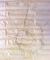
Map - Parker Williams Survey; Rebeca Murry Survey |
Search Terms |
Mouth of San Bernard River San Bernard River Gulf of Mexico Shoreline Cedar Lakes First Lake Survey map |
Scope & Content |
Map Black ink on linen Parker Williams Survey; Rebeca Murry Survey (near mouth of San Bernard River before construction of the Intracoastal Waterway). North arrow: yes North direction: toward upper-right corner of map Compass bearings: yes Scale: not shown Scale unit: vara Apparent scale: 500 feet/inch Prominent features: - Mouth San Bernard River - Gulf of Mexico shoreline - "First lake" (now the easterly basin of Cedar Lakes) Property owners: - Butler, W. H. - Murry, Rebeca - Williams, Parker |
Subjects |
Mouth of San Bernard River San Bernard River Gulf of Mexico Shoreline Cedar Lakes First Lake Survey map |
People |
Bass, Nan Butler, W.H. Murry, Rebeca Williams, Parker |
Extent of Description |
Paper: 13" wide x 17" high Image: 11" wide x 13" high |
Collection |
Nan Bass |
Accession number |
1988.070c |
Other number |
1988-70-70 |
Source |
Nan Bass |
Credit line |
Nan Bass |
Lexicon category |
8: Communication Artifact |
Catalog type |
Map |
Condition |
Fair |
Imagefile |
007\1988.070c.0070.JPG |
Number of images |
1 |
Relation |
Show Related Records... |