
Archive Record
Images
Metadata
Object Name |
Drawing |
Catalog Number |
1988.070c.0160 |
Title |
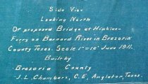
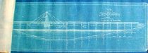
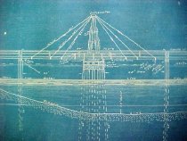
Engineering Drawing - South Elevation of former Hinckles Ferry Bridge |
Search Terms |
County Road 310 CR310 Farm to Market Road 2611 FM2611 Hinckles Ferry Hinckles-Ferry Road Hinkels Ferry Hinkle's Ferry Community San Bernard River |
Scope & Content |
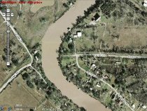
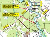
Engineering Drawing Blueprint -------------------------------------------------------------------------------------------- Side View Looking North of proposed Bridge at Hinkles Ferry on [San] Bernard River in Brazoria County. Built by Brazoria County. J. L. Chambers, Civil Engineer. -------------------------------------------------------------------------------------------- This bridge is no longer extant. The historic location of this bridge is in doubt. According to GNIS Database Interactive with Google Map, this bridge lies at the point where FM2611 crosses the San Bernard River. According to the Handbook of Texas' entry for "Hinkle's Ferry", the Hinkel's Ferry Community also lies at the point where FM2611 crosses the San Bernard River. In fact, Hinkle's Ferry Community lies at the point where Hinckle's (sic) Ferry Road (County Road 310) crosses the river. The USGS map for the Cedar Lane NE (TX) quadrangle confirms this. This might imply that the Hinkle's Ferry Bridge was at the same location, about a mile north of the FM2611 crossing. Neal |
Subjects |
County Road 310 CR310 Farm to Market Road 2611 FM2611 Hinckles Ferry Hinckles-Ferry Road Hinkels Ferry Hinkle's Ferry Community San Bernard River |
People |
Bass, Nan Chambers, J. Lee |
Extent of Description |
Paper: 35" wide x 12.5" high Image: 29" wide x 9" high |
Collection |
Nan Bass |
Accession number |
1988.070c |
Other number |
1988-70-160 |
Source |
Nan Bass |
Credit line |
Nan Bass |
Lexicon category |
8: Communication Artifact |
Catalog type |
Map |
Condition |
Fair |
Imagefile |
007\1988.070c.0160-1.JPG |
Number of images |
5 |