
Archive Record
Images
Metadata
Object Name |
Map |
Catalog Number |
1984.020c.0001 |
Title |
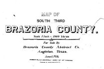
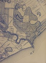
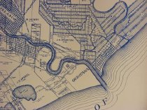
Map - South Third of Brazoria County |
Search Terms |
Bastrop Bayou Big Slough Brazoria Brazoria County Abstract Company Brazos River Bryan Lake Buffalo Camp Bayou Cedar Lake Bayou Cedar Lake Creek Cedar Lakes Christmas Bay Clute Cocklebur Slough Cow Trap Lake Cox Lake Ditch Lake Drum Bay East Union Bayou Freeport Gulf of Mexico Horseshoe Lake Hoskins Mound Houston and Brazos Valley Railway -- Hoskins Mound Spur Houston and Brazos Valley Railway International & Great Northern Railroad Gulf Intracoastal Waterway Lake Jackson Munson Lake Old Brazos River Old Ocean Oyster Bay Pelican Lake Railroad junctions Railroads Salt Lake San Bernard River St. Louis, Brownsville and Mexico Railway State Prison Farm Spur of SLB&MRY Stubblefield Lake Sweeny Velasco West Union Bayou |
Scope & Content |
Map - South Third of Brazoria County Diazotype whiteprint on paper Brazoria County Abstract Co. ------- TRANSCRIPT OF TITLE BLOCK ------- Map of South Third of Brazoria County Scale 1 inch = 1000 varas For sale by Brazoria County Abstract Co. Angleton, Texas June 1, 1936 Ownership believed substantially correct by not guaranteed Copyrighted 1936 Brazoria County Abstract Co. ------------------------------------------------------- North arrow: not shown North direction: top of map Compass bearings: no Scale: 1" = 1000 varas Scale Unit: Varas Prominent features: - Abstract numbers - Boundaries and names of original grants - Major waterways - Municipalities (see "Civil" below) - Property owners as of date of map - Railroad junctions - Railroads (see below) - Unincorporated communities (see "Civil" below) Civil: - Brazoria - Clute - Freeport - Sweeny - Velasco Railroads - Hoskins Mound Spur of H&BVRW - Houston & Brazos Valley Railway - International and Great Northern Railroad - St. Louis, Brownsville, & Mexico Railway - State Prison Farm Spur of SLB&MRY Waterways - Bastrop Bayou (not labeled) - Big Slough - Brazos River - Bryan Lake - Buffalo Camp Bayou - Cedar Lake Bayou (now Cedar Lake Creek) - Cedar Lakes - Cocklebur Slough - Cow Trap Lake - Cox Lake - Ditch Lake - Drum Bay - East Union Bayou - Gulf of Mexico - Horseshoe Lake - Intracoastal Waterway - Lake Jackson - Munson Lake - Old Brazos River - Old Ocean - Oyster Bay (now Christmas Bay) - Pelican Lake - Salt Lake - San Bernard River - Stubblefield Lake - West Union Bayou |
Date |
1936 |
Dates of Creation |
1936 |
Extent of Description |
96" wide x 37" high |
Collection |
James F. Parisian |
Accession number |
1984.020c |
Source |
James F. Parisian |
Credit line |
James F. Parisian |
Lexicon category |
8: Communication Artifact |
Catalog type |
Archive |
Imagefile |
028\1984020c0001.JPG |
Number of images |
3 |
Received date |
10/09/84 |