
Archive Record
Images
Metadata
Object Name |
Map |
Catalog Number |
1988.070c.0061 |
Title |
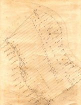
Map - property divisions on west side of San Bernard River just south of the north line of T. H. Bell League. |
Search Terms |
Bell League Bell, Mrs. Kate Hinkle, J. V. Hinkle's Ferry Map San Bernard River |
Scope & Content |
Map Pencil on drafting paper Property divisions on west side of San Bernard River just south of the north line of T. H. Bell League. Includes land now located between San Bernard River and CR 309 on both sides of CR 630 and 640. North arrow: no Apparent north direction: top of map Compass bearings: no Scale: not shown; apparent scale 1" = 400 feet Scale unit: feet Prominent features: - San Bernard River - "Bell Creek" (not the same waterway that we know today as Bell Creek) - North line of T. H. Bell League ("old ditch and fence") - Properties numbered 1-32. - Norris Place (also identified as "J. V. Hinkle 200 acres") Identified property owners: - Bell, Mrs. Kate - Hinkle, J. V. |
Subjects |
Bell League Bell, Mrs. Kate Hinkle, J. V. Hinkle's Ferry Map San Bernard River |
People |
Hinkle, J.V. Bass, Nan Bell, Kate [Jackson] |
Extent of Description |
Paper: 14" wide x 13" high Image: 11" wide x 11" high |
Collection |
Nan Bass |
Accession number |
1988.070c |
Other number |
1988-70-61 |
Source |
Nan Bass |
Credit line |
Nan Bass |
Lexicon category |
8: Communication Artifact |
Catalog type |
Map |
Condition |
Fair |
Imagefile |
007\1988.070c.0061.JPG |
Number of images |
1 |