Skip to content

Search Term Record

Metadata

Related Records

  1. Map - 1988.070c.0060

    Map - Samuel Carter league - Abstract No. 53.

    Record Type: Archive

    1988.070c.0060  Title Block
  2. Map - 1988.070c.0068

    Map - West Columbia and surrounding lands

    Record Type: Archive

    1988.070c..0068  Entire Map
  3. Map - 1988.070c.0136

    Map - Damon Mound including Damon townsite

    Record Type: Archive

    1988.070c.0136  Entire Map
  4. Map - 1988.070c.0137

    Map - Addition to City of Brazoria

    Record Type: Archive

    1988.070c.0137  Title Block
  5. Map - 1988.070c.0183

    Map - Texas Oil Exploration Co. Damon's Mound

    Record Type: Archive

    1988.070c.0183  Title Block
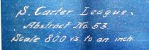
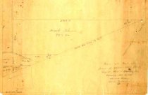
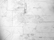
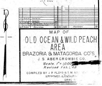
  6. Map - 1988.070c.0254

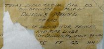
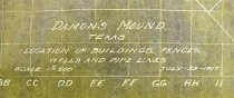
    Map - Damon's Mound Texas, Locations of Buildings Fences Wells and Pipe Lines.

    Record Type: Archive

    1988.070c.0254  Title Block
  7. Map - 1997.027c.0001

    Map - subdivisions of John H. Adams rice lands

    Record Type: Archive

    1997.027c.0001  Entire Map
  8. Map - 1998.013c.0001

    Map - Oil Leases in Northwest Half of Brazoria County

    Record Type: Archive

    1998.013c.0001  Title Block
  9. Map - 2008.017c.0001

    Map - Oil Leases in Peach Point Plantation

    Record Type: Archive

    2008.017c.0001  Detail - Central area of map
  10. Map - 2008.021c.0001

    Map - Oil lease map of northwest half Brazoria County

    Record Type: Archive

    2008.021c.0001  Detail - Columbia
  11. Map - 2008.030c.0001

    Map - Old Ocean & Wild Peach Area oil and gas leases

    Record Type: Archive

    2008.030c.0001  Title Block
  12. Map - 2009.004c.0001

    Map - West Columbia

    Record Type: Archive

    2009.004c.0001  Entire  Map

Thank You!

Confirmation Message Here....