
Archive Record
Images
Metadata
Object Name |
Map |
Catalog Number |
1997.027c.0001 |
Title |
Map - subdivisions of John H. Adams rice lands |
Search Terms |
Liverpool SH 36 |
Scope & Content |
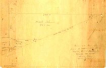
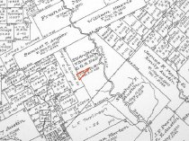
Map Map - subdivisions of John H. Adams rice lands Pencil on translucent drafting paper ------------------------------------------------------------------------------------------- Plat of Part of John H. Adams Rice Lands Angier, Hall, & Bradley League Surveyed March 14, 1940 Adriance Munson, County Surveyor JHR ------------------------------------------------------------------------------------------- North arrow: yes North direction: top of map clockwise 24 degrees Compass bearings: no Scale: Not shown; scales at 1" = 200 varas Scale unit: vara Prominent Features: - SH 35 (North ROW line) - Local road (unidentified) Property Owners and Leaseholders: - Adams, John H. - Hillers - Holt - Johnson, Frank |
Subjects |
Liverpool SH 36 |
People |
Adams, John Henry Adams, Lloyd Angier, Samuel Tubbs Bradley, Thomas W. Chambers, W.B. Hall, George B. Hillers Holt Johnson, Francis White "Frank" Munson, Adriance |
Date |
03/14/1940 |
Year Range from |
1940 |
Year Range to |
1940 |
Extent of Description |
Paper: 12.5" wide x 8.5" high Image: 12.5" wide x 8.5" high |
Collection |
Lloyd Adams |
Accession number |
1997.027c |
Source |
Lloyd Adams |
Lexicon category |
8: Communication Artifact |
Catalog date |
2007-09-06 |
Catalog type |
Archive |
Imagefile |
012\1997.027c.0001.jpg |
Number of images |
2 |
Received date |
12/13/1997 |