
Archive Record
Images


Metadata
Object Name |
Map |
Catalog Number |
1988.070c.0254 |
Title |
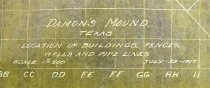
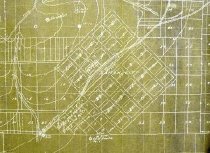
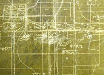
Map - Damon's Mound Texas, Locations of Buildings Fences Wells and Pipe Lines. |
Search Terms |
Damon townsite Damon Mound R.R. Grade SH 36 Cemetery Oil wells Oil leases |
Scope & Content |
Map Negative sepia print of 1988.070c.0183 Intended for use in making third-generation positive contact prints. _____________________________________________________ Damon's Mound Texas, Locations of Buildings Fences Wells and Pipe Lines. Scale 1" = 500" July 25, 1917 _____________________________________________________ North arrow: no North direction: - Top of map CCW 45 degrees on recto (emulsion side). - Top of map CW 45 degrees on verso. Compass bearings: no Scale: 1" = 500 feet Scale unit: feet Prominent features: - Contour lines - "Damon City" (Damon townsite) - Boundaries of oil leases - Buildings - Cemetery - Contour lines - Damon Mound - Fences - Oil Wells - Pipelines - "R.R. Grade" (now SH 36) |
Subjects |
Damon townsite Damon Mound R.R. Grade SH 36 Cemetery Oil wells Oil leases |
People |
Bass, Nan |
Dates of Creation |
1917 |
Year Range from |
1904 |
Year Range to |
1910 |
Extent of Description |
Paper: 35.5" wide x 39.5" high Image: 34" wide x 37.5" high |
Collection |
Nan Bass |
Accession number |
1988.070c |
Other number |
1988-70-254 |
Source |
Nan Bass |
Credit line |
Nan Bass |
Lexicon category |
8: Communication Artifact |
Catalog date |
2006-06-13 |
Catalog type |
Map |
Condition |
Fair |
Imagefile |
008\1988.070c.0254-1.jpg |
Number of images |
5 |
Relation |
Show Related Records... |