
Archive Record
Images
Additional Images [3]
Metadata
Object Name |
Map |
Catalog Number |
1998.013c.0001 |
Title |
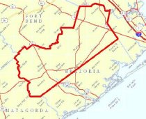
Map - Oil Leases in Northwest Half of Brazoria County |
Search Terms |
Algoa junction Alvin Alvin junction Anchor junction Archola junction Bailey's Prairie Baileys Prairie Bastrop Bayou Bonney Brazos River Chenango Chocolate Bayou Copperas Bayou Damon Dance Bayou Dance Sough Danciger Eagle Nest Lake East Columbia Edgar Tobin Aerial Surveys FM 521 FM 524 FM 1089 FM 1301 FM 1462 Gulf, Colorado, and Santa Fe Railroad Halls Bayou Hastings Houston and Brazos Valley Railway International & Great Northern Railroad Linneville Bayou Lone Star Saltwater Co. Manor Lake Manvel Oil leases Oil pipeline Oil wells Oyster Bayou Oyster Creek Pearland Rosharon San Bernard River Sandy Point Sweeny Scoby Lake SH 6 SH 288 SH 36 St. Louis, Brownsville and Mexico Railway Sugarland Railroad Thurmond Lake Toleman Tolman Union Pacific Railroad Varner Creek Varner's Creek Velasco, Brazos and Northern Railway West Columbia Wild Peach |
Scope & Content |
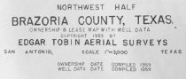
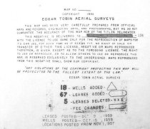
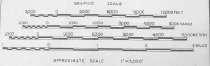
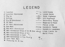
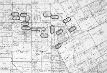
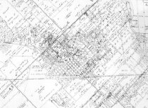
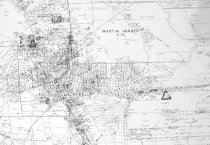
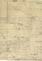
Map Oil lease map of northwest half Brazoria County with index of property owners and townsites Diazotype whiteprint ------------------------------------------------------------------------------------- Northwest One Half Brazoria County Texas Ownership & Lease Map with Well Data Copyright 1959 by Edgar Tobin Aerial Surveys San Antonio, Texas Scale 1" = 3,000' Ownership Date Compiled 1959 Well Data Compiled 1959 ------------------------------------------------------------------------------------- North arrow: yes North direction: top of map clockwise about 40 degrees Compass bearings: no Scale: 1" = 3000 feet Scale unit: feet Prominent Features: - Abstract Numbers - Canal (Lone Star Saltwater Co.) - Communities and townsites (see below) - County lines - Domes (oil, salt) - Oil leases - Oil pipeline - Oil wells - Original League Boundaries and names - Property Boundaries - Railroads and junctions (see below) - Roads (see below) - Waterways (see below) Townsites: - Alvin townsite - Bailey's Prairie Townsite - Bonney townsite - Chenango townsite - Chocolate Bayou townsite - Damon Townsite - Danciger Townsite - East Columbia townsite - Hastings townsite - Manvel townsite - Pearland townsite - Rosharon townsite - Sandy Point townsite - Sweeny townsite - Tolman (Toleman) townsite - West Columbia townsite - Wild Peach subdivision Railroads: - Gulf, Colorado, and Santa Fe Railroad (now BNSF) - Houston & Brazos Valley Railroad - International & Great Northern Railroad (no longer extant south of SH6) - St. Louis, Brownsville, and Mexico Railway (now UPRR) - Sugarland Railroad (no longer extant) - Velasco Brazos and Northern Railway Railroad junctions: - Algoa junction - Alvin junction - Anchor junction - Archola junction - Sugarland crossing Roads: - FM 1089 (now FM 524) - FM 1301 - FM 1462 - FM 521 (south of Bailey's Prairie) - Old SH 288 (now FM 521 north of Bailey's Prairie) - SH 35 - SH 36 - SH 6 Waterways (partial list): - Bastrop Bayou - Brazos River - Copperas Bayou - Dance Sough (now Dance Bayou) - Eagle Nest Lake - Halls Bayou - Linneville Bayou - Manor Lake - Oyster Bayou (now Oyster Creek) - San Bernard River - Scoby Lake - Thurmond Lake - Varner's Creek (now Varner Creek) |
Subjects |
Algoa junction Alvin Alvin junction Anchor junction Archola junction Bailey's Prairie Baileys Prairie Bastrop Bayou Bonney Brazos River Chenango Chocolate Bayou Copperas Bayou Damon Dance Bayou Dance Sough Danciger Eagle Nest Lake East Columbia Edgar Tobin Aerial Surveys FM 521 FM 524 FM 1089 FM 1301 FM 1462 Gulf, Colorado, and Santa Fe Railroad Halls Bayou Hastings Houston & Brazos Valley Railroad International & Great Northern Railroad Linneville Bayou Lone Star Saltwater Co. Manor Lake Manvel Oil leases Oil pipeline Oil wells Oyster Bayou Oyster Creek Pearland Rosharon San Bernard River Sandy Point Sweeny Scoby Lake SH 6 SH 288 SH 36 St. Louis, Brownsville, and Mexico Railway Sugarland Railroad Thurmond Lake Toleman Tolman Union Pacific Railroad UPRR Varner Creek Varner's Creek Velasco Brazos and Northern Railway West Columbia Wild Peach |
People |
Adams, Lloyd Tobin, Edgar |
Date |
1959 |
Dates of Creation |
1959 |
Extent of Description |
Paper: 107" wide x 43" high Image: 105" wide x 43" high |
Collection |
Found in collection |
Accession number |
1998.013c |
Source |
Lloyd Adams |
Lexicon category |
8: Communication Artifact |
Catalog date |
2008-05-30 |
Catalog type |
Archive |
Imagefile |
013\1998.013c.0001-01.jpg |
Number of images |
9 |
Relation |
Show Related Records... |
Received date |
03/11/98 |