
Person Record
Metadata
Name |
Munson |
Related Records
-

-
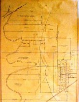
Map - 1988.070c.0057
Map - Area along "Columbia Road" (now SH35) between Angleton and Bailey's Prairie.
Record Type: Archive
-
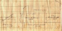
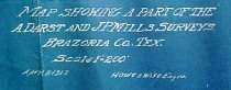
Map - 1988.070c.0064
Map - division of the H. L. and T. H. Bryan property in the A. Darst and J. P. Mills surveys
Record Type: Archive
-
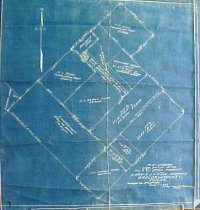
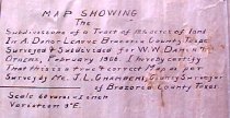
Map - 1988.070c.0065
Map - subdivisions of a tract of 12.5 acres of land in Abraham Darst league
Record Type: Archive
-
-
-
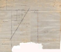
Map - 1988.070c.0150
Map - Subdivisions of Abraham Darst and John P. Mills Surveys
Record Type: Archive
-
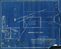
Map - 1988.070c.0152
Map - South Texas Development Company land in Carter League, Bailey League, and Russell Labor.
Record Type: Archive
-
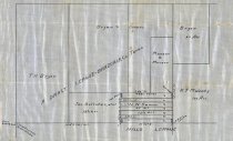
Map - 1988.070c.0154
Map - Subdivisions of lands located in the Abraham Darst league west of Community of Damon.
Record Type: Archive
-
-
-
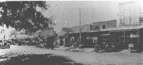
Print, Photographic - 1984.023p.0004a
Panoramic view of a West Columbia street. Showing: Buildings: - Albert Halbary (?) Barber Shop - B. Daily Drygoods, Furnishings, Shoes - Columbia State Bank - Dr Nowles - E.L. Beckwith Taylor Laundry Cleaning & Pressing - Everybody's Department Store Shoes and Drygoods - Ice - Model Laundry, The - Munson's Meat Market - West Columbia Lighting and Power, J. Renfro, Mgr Vehicles: - Horse-drawn cart - L.H. Fisher, Transfer - Hor...
Record Type: Photo
-
-