
Archive Record
Images
Metadata
Object Name |
Map |
Catalog Number |
1988.070c.0057 |
Title |
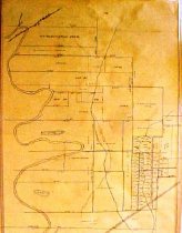
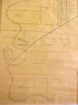
Map - Area along "Columbia Road" (now SH35) between Angleton and Bailey's Prairie. |
Search Terms |
Angleton, Texas Baileys Prairie Columbia Road Maps -- Angleton, Texas. Maps -- Bailey's Prairie, Texas. Cornelius Smith League FM521 Highway International & Great Northern Railroad Map Oyster Creek Railroad Retrieve Plantation Roberts Labor SH 35 Smith League St. Louis, Brownsville and Mexico Railway State Highway 35 Union Pacific Railroad Ward Lake |
Scope & Content |
Map Black ink on opaque drafting paper Area along "Columbia Road" (now SH35) between Angleton and Bailey's Prairie. North arrow: no North direction: toward top of map Compass bearings: yes (a few) Scale: not shown Scale unit: feet Apparent scale: 1000 feet/inch Prominent features: - Oyster Creek - St Louis Brownsville & Mexico RR (now UPRR) - International & Great Northern RR (now Highway FM521) - Ward Lake - Several other small lakes - Columbia Road (now SH35) - A Roberts Labor - Cornelius Smith League (partial) - Retrieve Plantation (partial) Property owners: - Abraham - Cox, C.R. - Jamison heirs - Jamison, D. B. - Jamison, S.J. - Munson - Neidringhaus, N. F. - Perry - Roberts, A. - Roberts, Noel F. - Smith, Cornelius - Sproles & Volbum - Swisher, J.M. |
Subjects |
Maps -- Angleton, Texas. Maps -- Bailey's Prairie, Texas. |
People |
Bass, Nan Abraham Cox, C.R. Jamison, D.B. Jamison, S.J. Munson Neidringhaus, N.F. Perry Roberts, A. Roberts, Noel Francis Smith, Cornelius Sproles Swisher, J.M. Volbum |
Extent of Description |
Sheet: 36" high x 17.5" wide Image: 35" high x 16" wide |
Medium |
Black Ink on ecru paper |
Collection |
Nan Bass |
Accession number |
1988.070c |
Other number |
1988-70-57 |
Source |
Nan Bass |
Credit line |
Nan Bass |
Lexicon category |
8: Communication Artifact |
Catalog type |
Map |
Condition |
Good |
Condition Notes |
Minor tear on top edge. Rolled. |
Condition date |
2030-05-11 |
Imagefile |
007\1988.070c.0057-1.JPG |
Number of images |
2 |
Size |
Pg & Im 36" x 17.5" |
No. of sheets |
1 |
Area / Region |
Brazoria County, between Angleton and Bailey's Praire, along SH35. |
Map Language |
English |
Insets |
none |
North Latitude |
29.2° |
West Longitude |
95.4° |
Prime meridian |
Greenwich |