
Archive Record
Images
Metadata
Object Name |
Map |
Catalog Number |
1988.070c.0152 |
Title |
Map - South Texas Development Company land in Carter League, Bailey League, and Russell Labor. |
Search Terms |
Bailey's Prairie Brazoria Road Cornelius Smith League FM 521 James Bailey League Oyster Creek Rice farm Russell Labor Samuel Carter League SH 35 |
Scope & Content |
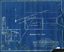
Map Blueprint ---------------------------------------------------------------------------------- Plat showing Land Belonging to the South Texas Development Co. Also In West end of Collins Trat out of Cornelius Smith League In Bennett Tract out of Carter & Bailey Leagues & Russell Labor. Scale 1 inch = 400 varas. June 24, 1905 J. A Donaldson, Surveyor ---------------------------------------------------------------------------------- North arrow: yes North direction: top of map Compass bearings: yes Scale: 1" = 400 varas Scale unit: vara Prominent features: - Angleton-Columbia Road (now SH 35) - Brazoria Road (now FM 521) - Cornelius Smith League - James Bailey League - Monson's Rice Farm - Oyster Creek - Russell Labor - Samuel Carter League - South Texas Development Company Property owners and leaseholders: - Collins - Munson - South Texas Development Company |
Subjects |
- Bailey's Prairie - Brazoria Road - Cornelius Smith League - FM 521 - James Bailey League - Oyster Creek - Rice farm - Russell Labor - Samuel Carter League - SH 35 |
People |
Bailey, James Briton "Brit" Bass, Nan Carter, Samuel Collins Donaldson, J.A. Munson Russell, William J. Smith, Cornelius |
Date |
06/24/1905 |
Dates of Creation |
06/24/1905 |
Extent of Description |
Paper: 13.5" wide x 11" high Image: 13" wide x 10.5" high |
Collection |
Nan Bass |
Accession number |
1988.070c |
Other number |
1988-70-152 |
Source |
Nan Bass |
Credit line |
Nan Bass |
Lexicon category |
8: Communication Artifact |
Catalog type |
Map |
Condition |
Fair |
Imagefile |
007\1988.070c.0152.JPG |
Number of images |
1 |