
Archive Record
Images
Metadata
Object Name |
Map |
Catalog Number |
1988.070c.0064 |
Title |
Map - division of the H. L. and T. H. Bryan property in the A. Darst and J. P. Mills surveys |
Search Terms |
Blueprint map plat survey H. L. and T. H. Bryan property A. Darst and J. P. Mills surveys Brazoria County, Texas McNeal, P.L.D. League |
Scope & Content |
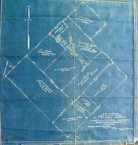
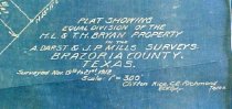
Map Cyanotype Blueprint --------------------------------------------------------------------------------------------- Plat showing equal division of the H. L. and T. H. Bryan property in the A. Darst and J. P. Mills surveys, Brazoria County, Texas. Surveyed Nov. 19th to 21st 1912. Scale: 1"=300' Clifton Rice, C.E., Richmond, Texas. R.W.G., dpty. --------------------------------------------------------------------------------------------- North arrow: yes North direction: top of map Compass bearings: yes Scale: 1" = 300 feet Scale unit: feet Property Owners: - Bryan, George - Bryan, H.L. & T.H. - Bryan, T.H. Estate - Damon, W.W. - McNeal, P.L.D - Munson |
Subjects |
Blueprint map plat survey H. L. and T. H. Bryan property A. Darst and J. P. Mills surveys Brazoria County, Texas McNeal, P.L.D. League |
People |
Bass, Nan Bryan, George Bryan, H.L. Bryan, T.H. Bunker, A. Damon, W.W. Darst, A. McNeal, P.L.D. Mills, John P. Munson Rice, Clifton |
Extent of Description |
Paper: 15.5" wide x 17/5" high Image: 16.5" wide x 16.3" high |
Collection |
Nan Bass |
Accession number |
1988.070c |
Other number |
1988-70-64 |
Source |
Nan Bass |
Credit line |
Nan Bass |
Lexicon category |
8: Communication Artifact |
Catalog date |
1912-01-01 |
Catalog type |
Map |
Condition |
Fair |
Imagefile |
007\1988.070c.0064-1.JPG |
Number of images |
2 |