Skip to content

Search Term Record

Metadata

Related Records

  1. Map - 1988.070c.0039

    Map - Drainage District No. 5

    Record Type: Archive

    1988.070c.0039  Title Block
  2. Map - 1988.070c.0138

    Map - Drainage District No. 5

    Record Type: Archive

    1988.070c.0037.0138  Title Block
  3. Map - 1995.016c.0002

    Map - Oil lease map of northwest half Brazoria County

    Record Type: Archive

    1995.016c.0002-01  Title Block
  4. Map - 1998.013c.0001

    Map - Oil Leases in Northwest Half of Brazoria County

    Record Type: Archive

    1998.013c.0001  Title Block
  5. Map - 2007.011c.0001

    1940 Road Map of Brazoria County

    Record Type: Archive

    1940 Brazoria County Road Map
  6. Map - 2008.021c.0001

    Map - Oil lease map of northwest half Brazoria County

    Record Type: Archive

    2008.021c.0001  Detail - Columbia
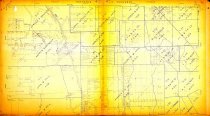
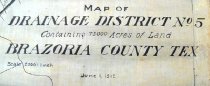
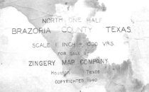
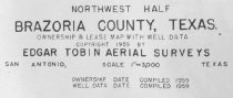
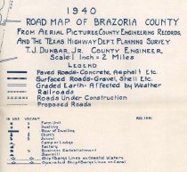
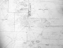
  7. Map - 2009.024c.0030

    Map - Rosharon USGS quadrangle - Title Services Inc. Plat Map

    Record Type: Archive

    2009.024c.0030 North Half

Thank You!

Confirmation Message Here....