
Archive Record
Images
Additional Images [10]
Metadata
Object Name |
Map |
Catalog Number |
1995.016c.0002 |
Title |
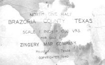
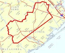
Map - Oil lease map of northwest half Brazoria County |
Search Terms |
Algoa junction Alvin American National Life Insurance Co. Anchor junction Archola junction Argonne Oil & Investment Co. Bailey's Prairie Baker Lindsey Oil Co. Barnsdall Oil. Co. Bastrop Bayou Bernard River Land Development Co. Bonney Brazoria County State Bank Brazos River Chenango Chocolate Bayou Chocolate Bayou community Coastal Oil Finding Co. Copperas Bayou Crown Oil & Refining Co. Damon community Damon Mound West Columbia Co. Danciger Oil & Refining Co. Day Land and Cattle Co. Eagle Nest Lake East Columbia Gulf Products Co. Gulf, Colorado, and Santa Fe Railroad Halls Bayou Hardin subdivision Hastings Hogg Oil Houston and Brazos Valley Railway Houston Farms Development Company Humble International & Great Northern Railroad Liberty Land and Investment Co. Linneville Bayou Magnolia Petroleum Corp. Manor Lake Manvel Osceola Irrigation Co. Oyster Bayou Oyster Creek Pearland Pure Oil. Co. Rosharon San Bernard River Sandy Point Scoby Lake Second National Bank Shell Petroleum Co. Skelly Oil. Co. St. Louis, Brownsville and Mexico Railway Sugarland crossing Sugarland Railroad Sweeny Texas Co. Texas Insurance and Investment Co. Thurmond Lake Toleman Tolman Varner Creek Velasco, Brazos and Northern Railway West Columbia Wild Peach subdivision Zingery Map Co. Zionville Oil Co. |
Scope & Content |
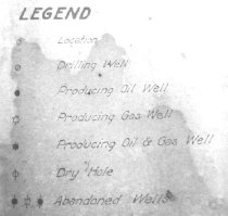
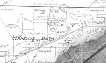
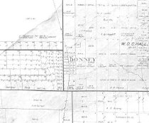
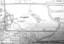
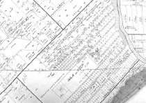
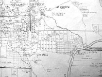
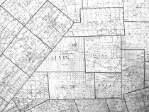
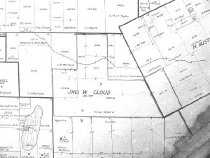
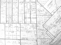
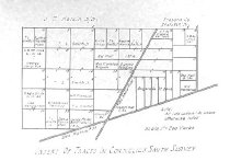
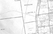
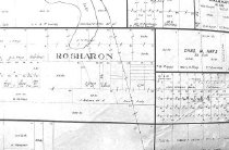
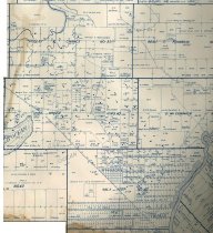
Map Oil well map of northwest half Brazoria County with index of property owners and townsites Diazotype whiteprint with colored pencil overwrite ------------------------------------------------------------------------------------- North One Half Brazoria County Texas Scale 1 inch = 1000 Vrs. For Sale By Zingery Map Company Houston, Texas Copyrighted 1940 ------------------------------------------------------------------------------------- North arrow: yes North direction: top of map clockwise 45 degrees Compass bearings: no Scale: 1" = 1000 varas Scale unit: vara Prominent Features: - Abstract Numbers - Communities and townsites (see below) - County lines - Domes (oil, salt) - Oil wells - Original League Boundaries and names - Property Boundaries - Railroads and junctions (see below) - Roads and streets - Waterways (see below) Townsites: - Alvin townsite - Bonney townsite - Chenango townsite - Chocolate Bayou townsite - Damon Townsite - East Columbia townsite - Hardin subdivision (now Bailey's Prairie) - Hastings townsite - Manvel townsite - Pearland townsite - Rosharon townsite - Sandy Point townsite - Sweeny townsite - Tolman (Toleman) townsite - West Columbia townsite - Wild Peach subdivision Railroads: - Gulf, Colorado, and Santa Fe Railroad - Houston & Brazos Valley Railroad - International & Great Northern Railroad - St. Louis, Brownsville, and Mexico Railway - Sugarland Railroad - Velasco Brazos and Northern Railway Railroad junctions: - Algoa junction - Alvin junction - Anchor junction - Archola junction - Sugarland crossing Waterways (partial list): - Bastrop Bayou - Brazos River - Copperas Bayou - Eagle Nest Lake - Halls Bayou - Linneville Bayou - Manor Lake - Oyster Bayou (now Oyster Creek) - San Bernard River - Scoby Lake - Thurmond Lake - Varner's Creek (now Varner Creek) Companies (partial list): - American National Life Insurance Co. - Argonne Oil & Investment Co. - Baker Lindsey Oil Co. - Barnsdall Oil. Co. - Bernard River Land Development Co. - Brazoria County State Bank - Coastal Oil Finding Co. - Crown Oil & Refining Co. - Damon Mound West Columbia Co. - Danciger Oil & Refining Co. - Day Land and Cattle Co. - Gulf Products Co. - Hogg Oil - Houston Farms Development Co. - Humble - Liberty Land and Investment Co. - Lone Star Salt Water Co. - Magnolia Petroleum Corp. - Osceola Irrigation Co. - Pure Oil Co. - Second National Bank - Shell Petroleum Co. - Skelly Oil. Co. - Texas Co. - Texas Insurance and Investment Co. - Zionville Oil Co. |
Subjects |
Algoa junction Alvin American National Life Insurance Co. Anchor junction Archola junction Argonne Oil & Investment Co. Bailey's Prairie Baker Lindsey Oil Co. Barnsdall Oil. Co. Bastrop Bayou Bernard River Land Development Co. Bonney Brazoria County State Bank Brazos River Chenango Chocolate Bayou Chocolate Bayou community Coastal Oil Finding Co. Copperas Bayou Crown Oil & Refining Co. Damon community Damon Mound West Columbia Co. Danciger Oil & Refining Co. Day Land and Cattle Co. Eagle Nest Lake East Columbia Gulf Products Co. Gulf, Colorado, and Santa Fe Railroad Halls Bayou Hardin subdivision Hastings Hogg Oil Houston & Brazos Valley Railroad Houston Farms Development Co. Humble International & Great Northern Railroad Liberty Land and Investment Co. Linneville Bayou Magnolia Petroleum Corp. Manor Lake Manvel Osceola Irrigation Co. Oyster Bayou Oyster Creek Pearland Pure Oil. Co. Rosharon San Bernard River Sandy Point Scoby Lake Second National Bank Shell Petroleum Co. Skelly Oil. Co. St. Louis, Brownsville, and Mexico Railway Sugarland crossing Sugarland Railroad Sweeny Texas Co. Texas Insurance and Investment Co. Thurmond Lake Toleman Tolman Varner Creek Velasco Brazos and Northern Railway West Columbia Wild Peach subdivision Zingery Map Co. Zionville Oil Co. |
People |
Tyson, J.R. Zingery |
Date |
1940 |
Dates of Creation |
1940 |
Year Range from |
1940 |
Year Range to |
1940 |
Extent of Description |
Paper: 104" wide x 42" high Image: 103" wide x 41" high |
Collection |
J.R. Tyson |
Accession number |
1995.016c |
Source |
Mr. Jr. R. Tyson |
Lexicon category |
8: Communication Artifact |
Catalog date |
2006-11-17 |
Catalog type |
Archive |
Imagefile |
011\1995.016c.0002-01.jpg |
Number of images |
16 |
Relation |
Show Related Records... |
Received date |
07/25/1995 |