
Archive Record
Images
Metadata
Object Name |
Map |
Catalog Number |
2007.011c.0001 |
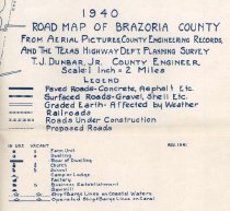
Title |
1940 Road Map of Brazoria County |
Search Terms |
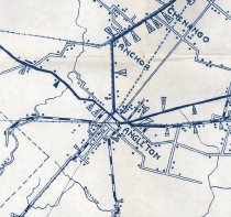
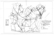
Alvin Anchor Angleton Bastrop Bay Bastrop Bayou BNSF Railroad Bonney Brazoria Brazos River Cedar Creek Chenango Chocolate Bayou Christmas Bay Clear Lake Creek Clute County Engineer Danbury Freeport Gulf of Mexico Halls Bayou Houston and Brazos Valley Railway International & Great Northern Railroad Gulf Intracoastal Waterway Iowa Colony Linnville Bayou Liverpool Manvel Missouri Pacific Railroad Mount Creek Mustang Bayou Oyster Bay Oyster Creek Pearland Rosharon San Bernard River Sandy Point Santa Fe Railroad SH288 SH288B SH35 SH36 St. Louis, Brownsville and Mexico Railway Sweeny Texas Highway Dept. Union Pacific Railroad Velasco West Bay West Columbia |
Scope & Content |
Map - Brazoria County Road Map 1940 Diazotype whiteprint ---------------- TRANSCRIPT OF TITLE BLOCK --------- 1940 Map of Brazoria County From Aerial Pictures, County Engineering Records, And the Texas Highway Dept. Planning Survey. T.J. Dunbar, County Engineer Scale: 1 inch = 2 Miles --------------------------------------------------------------------------- North arrow: yes North direction: top of map clockwise 48 degrees Compass bearings: none shown Scale: 1" = 2 miles Scale Unit: Miles Civil: - Alvin - Anchor - Angleton - Bonney - Brazoria - Chenango - Clute - Danbury - Freeport - Iowa Colony - Liverpool - Manvel - Pearland - Rosharon - Sandy Point - Sweeny - Velasco - West Columbia Transportation Infrastructure shown on map (not labeled): - Houston & Brazos Valley Railway - International and Great Northern Railroad - SH288 (now SH288B) - SH35 - SH36 - St. Louis, Brownsville, & Mexico Railway Waterways: - Bastrop Bay - Bastrop Bayou - Brazos River - Cedar Creek - Chocolate Bayou - Clear Lake Creek - Gulf of Mexico - Halls Bayou - Intracoastal Canal - Linnville Bayou (not labeled) - Mount Creek - Mustang Bayou - Oyster Bay - Oyster Creek - San Bernard River - West Bay (now Christmas Bay) |
Subjects |
1940 Brazoria County Cities Map Municipalities Railroads Roads Towns Waterways |
People |
Dunbar, T.J. |
Date |
1941 |
Dates of Creation |
1941 |
Year Range from |
1937 |
Year Range to |
1941 |
Extent of Description |
Paper: 36" wide x 24" high Image: 33" wide x 21" high |
Pub Date |
1941 |
Pub Place |
Angleton, TX |
Collection |
BCHM |
Accession number |
2007.011c |
Source |
BCHM Verticle Info Files |
Credit line |
Brazoria County Historical Museum |
Lexicon category |
8: Communication Artifact |
Catalog date |
2007-04-09 |
Catalog type |
Map |
Condition |
Good |
Condition date |
2007-04-09 |
Imagefile |
020\2007.011c.0001.JPG |
Number of images |
3 |
Size |
23 x 36 |
Classification |
Documentary Artifact |
Area / Region |
Brazoria County |
Inventoried date |
2007-04-09 |
Map Language |
English |
Scale |
1 inch = 2 Miles |
Publisher |
Brazoria County Engineer |
Received date |
04/09/2007 |