Skip to content

Search Term Record

Metadata

Related Records

  1. Blueprint - 1988.070c.0158

    Map - E.P.Myrick League 100-acre subdivision

    Record Type: Archive

    1988.070c.0158  Title Block
  2. Map - 1984.020c.0002

    Map - Middle Third of Brazoria County

    Record Type: Archive

    1984.020c.0002  Title Block
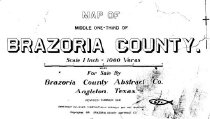
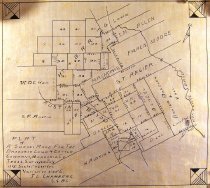
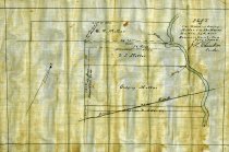
  3. Map - 1988.070c.0002

    Map - Subdivisions of Henry Austin League between Austin Bayou and Brushy Bayou

    Record Type: Archive

    Survey Map
  4. Map - 1988.070c.0039

    Map - Drainage District No. 5

    Record Type: Archive

    1988.070c.0039  Title Block
  5. Map - 1988.070c.0044

    Map - Henry Austin league No.4

    Record Type: Archive

    1988.070c.0044  Title Block
  6. Map - 1988.070c.0047

    Map - Brazoria Land & Cattle Company, Brazoria Co. Texas.

    Record Type: Archive

    1988.070c.0047  Entire Map
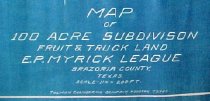
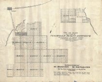
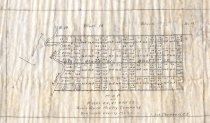
  7. Map - 1988.070c.0050

    Map - First and Second Sections of Texas Gulf Realty Company's Subdivision

    Record Type: Archive

    1988.070c.0050
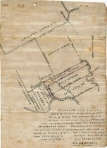
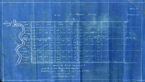
  8. Map - 1988.070c.0105

    Map - Sketch map and field notes for F.M.Harvin Tract 441.7-acre tract.

    Record Type: Archive

    1988.070c.0105  Plat Map
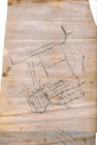
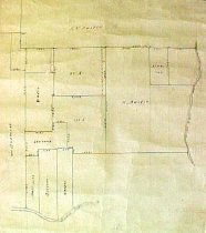
  9. Map - 1988.070c.0107

    Map - Subdivision of lands near Liverpool; preliminary pencil sketch for Port Brazos

    Record Type: Archive

    1988.070c.0107  Entire Map
  10. Map - 1988.070c.0115

    Map - Ink study for 1988.070.0115c.

    Record Type: Archive

    1988.070c.0115  Entire Mpa
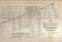
  11. Map - 1988.070c.0117

    Map - Texas-Gulf Realty Company subdivision of Orchard and Truck Lands

    Record Type: Archive

    1988.070c.0117  TGRC Lands
  12. Map - 1988.070c.0120

    Map - Bruner, Hayes, and Shapard properties

    Record Type: Archive

    1988.070c.0120  Title Block
  13. Map - 1988.070c.0124

    Map - Jas.J. West and Chas. W. Melbern Subdivision

    Record Type: Archive

    1988.070c.0124  Title Block
  14. Map - 1988.070c.0138

    Map - Drainage District No. 5

    Record Type: Archive

    1988.070c.0037.0138  Title Block
  15. Map - 1988.070c.0139

    Map

    Record Type: Archive

  16. Map - 1988.070c.0143

    Map - Plat of The Estate of Godfrey Moller

    Record Type: Archive

    1988.070c.0143  Map
  17. Map - 1988.070c.0146

    Map - Texas Gulf Realty Co. Blocks 17, 18, 19.

    Record Type: Archive

    1988.070c.0146  Entire Map
  18. Map - 1988.070c.0157

    Map - Ink Study for 1988.070c.0185 - A.J.Watts Survey

    Record Type: Archive

    1988.070c.0157  Entire Map
  19. Map - 1988.070c.0161

    Map - Texas Gulf Realty Co. Logs 20, 22, 22

    Record Type: Archive

    1988.070c.0161 Entire Map
  20. Map - 1988.070c.0171

    Map - Texas-Gulf Realty Company Lots 4, 5, and 6 including partial Danbury townsite

    Record Type: Archive

    1988.070c.0171  Entire Map

Thank You!

Confirmation Message Here....