
Archive Record
Images
Metadata
Object Name |
Map |
Catalog Number |
1988.070c.0157 |
Title |
Map - Ink Study for 1988.070c.0185 - A.J.Watts Survey |
Search Terms |
Austin Bayou Bastrop Bayou Bastrop Bayou Acres (community) Brushy Bayou Henry Austin 13 Labors Houston Tap and Brazoria Railway McCormack Reservoir South Texas Development Company |
Scope & Content |
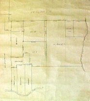
Map Ink Study for 1988.070c.0185 A.J.Watts Survey North arrow: yes North direction: top of map clockwise 27 degrees Compass bearings: yes (east line of map) Scale: not shown; 1" = 500 vara Scale unit: vara Prominent Features: - Austin Bayou (eastern boundary of mapped area) - Bastrop Bayou (southern boundary of mapped area) - Henry Austin 13 Labors tract of October 6, 1835 - STDC tract within former Henry Austin 13 Labors tract Brushy Bayou crosses this map but is not shown. McCormack Reservoir now covers part of the land shown on this map. Property owners: - Austin, Henry - Carter - Houston Tap & Brazoria Railroad (Section 1) - McDermott, William - Osborne - South Texas Development Company - Stevens - Watts, A.J. |
Subjects |
Austin Bayou Bastrop Bayou Bastrop Bayou Acres (community) Brushy Bayou Henry Austin 13 Labors Houston Tap & Brazoria Railroad HTBRR McCormack Reservoir South Texas Development Company STDC |
People |
Austin, Henry Carter McDermott, William Osborne Stevens Watts, A.J. |
Extent of Description |
Paper: 16" wide x 21" high Image: 15" wide x 17" high |
Collection |
Nan Bass |
Accession number |
1988.070c |
Other number |
1988-70-157 |
Source |
Nan Bass |
Credit line |
Nan Bass |
Lexicon category |
8: Communication Artifact |
Catalog type |
Map |
Condition |
Fair |
Imagefile |
007\1988.070c.0157.JPG |
Number of images |
2 |
Relation |
Show Related Records... |