
Archive Record
Images
Metadata
Object Name |
Map |
Catalog Number |
1988.070c.0146 |
Title |
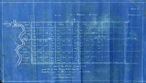
Map - Texas Gulf Realty Co. Blocks 17, 18, 19. |
Search Terms |
Austin Bayou Block 17 Block 18 Block 19 Gulf Coast Realty Co. Hiram H. Russell Survey |
Scope & Content |
Map Blueprint map ------------------------------------------------------------------------------------------- West 1/2 of Block 17, all of 19 and 18, of the Texas Gulf Realty Co.'s Subdivision in Brazoria County, Texas. Scale 1" = 2000' J. Lee Chambers, Civil Engineer ------------------------------------------------------------------------------------------- North arrow: North direction: top of map clockwise 27 degrees Compass bearings: no Scale: 1" = 2000 feet Scale unit: feet Prominent features: - Austin Bayou - Hiram H. Russell Survey |
Subjects |
Austin Bayou Block 17 Block 18 Block 19 Gulf Coast Realty Co. Hiram H. Russell Survey |
People |
Bass, Nan Chambers, J. Lee Russell, Hiram H. Stockton, W.C. |
Extent of Description |
Paper: 16" wide x 9" high Image: 15" wide x 8.5" high |
Collection |
Nan Bass |
Accession number |
1988.070c |
Other number |
1988-70-146 |
Source |
Nan Bass |
Credit line |
Nan Bass |
Lexicon category |
8: Communication Artifact |
Catalog type |
Map |
Condition |
Fair |
Imagefile |
007\1988.070c.0146.JPG |
Number of images |
1 |