Skip to content

Search Term Record

Metadata

Related Records

  1. Deed - 1986.047c.0043

    Deed of trust for conveyance of land

    Record Type: Archive

    1986.047c.0043  Page 4
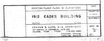
  2. Drawing, Architectural - 2014.015c.0002

    Eades Building - Sweeny - Existing Floor Plans and Elevations

    Record Type: Archive

    2014.015c.0002  Title Block
  3. Map - 1988.070c.0008

    Map - Pencil study for 1988.070c.0173

    Record Type: Archive

    Map - Pencil study for 1988.070c.0173
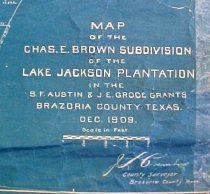
  4. Map - 1988.070c.0018

    Map - Charles E Brown subdivision of the Lake Jackson Plantation

    Record Type: Archive

    1988.070c.0018  Title Block
  5. Map - 1988.070c.0029

    Map - Retrieve and Lake Jackson plantation

    Record Type: Archive

    1988.070c.0029  Title Block
  6. Map - 1988.070c.0040

    Map - "Tracts left out of Charles J. Horn Subdivision at Velasco"

    Record Type: Archive

    1988.070c.0040  Cover
  7. Map - 1988.070c.0042

    Map - Blueprint of 1988.070c.0168

    Record Type: Archive

    1988.070c.0042  Title Block
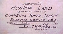
  8. Map - 1988.070c.0046

    Map - Cornelius Smith League & adjoining surveys as located by the Courts

    Record Type: Archive

    1988.070c.0046
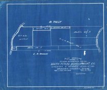
  9. Map - 1988.070c.0052

    Map - South Texas Development Co. out of the Chester S. Gorbet League

    Record Type: Archive

    1877.070c.0052  Entire map
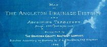
  10. Map - 1988.070c.0053a, b

    Map - Angleton Drainage District and Adjoining Territory. Letter - Recommendation of J. Lee Chambers d Letter of Recommendation

    Record Type: Archive

    1988.070c.0053a Title Block
  11. Map - 1988.070c.0057

    Map - Area along "Columbia Road" (now SH35) between Angleton and Bailey's Prairie.

    Record Type: Archive

    1988.070c-0057  North End
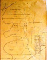
  12. Map - 1988.070c.0069

    Map - Mary Scoby 775 acres survey in C.Smith Lg.Brazoria Co. Tex. & the original subdivisions.

    Record Type: Archive

    1988.070c.0069  Front
  13. Map - 1988.070c.0074

    Map - D.L.Abraham Survey

    Record Type: Archive

    1988.070c.0074  Title Block
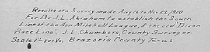
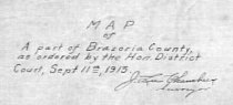
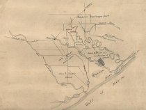
  14. Map - 1988.070c.0077

    Map - Part of Brazoria County as ordered by the Hon. District Court

    Record Type: Archive

    1988.070c.0077  Title Block
  15. Map - 1988.070c.0088

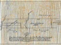
    Map - land formerly in Lake Jackson Plantation bounded by Buffalo Bayou, Brazos River, and Oyster Creek

    Record Type: Archive

    1988.070c.0088
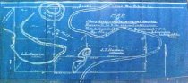
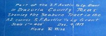
  16. Map - 1988.070c.0096

    Map - Seaburn Tract in NE corner S.F.Austion 1/2 league grant

    Record Type: Archive

    1988.070c.0096  Title Block
  17. Map - 1988.070c.0102

    Map - Munson land in west end of Cornelius Smith league

    Record Type: Archive

    1988.070c.0102  Title Block
  18. Map - 1988.070c.0103

    Map - Bailey & Roberts Survey subdivisions

    Record Type: Archive

    1988.070c.0103  Title Block
  19. Map - 1988.070c.0112

    Map - Blueprint of 1988.070c.0170

    Record Type: Archive

    1988.070c.0112 Title Block
  20. Map - 1988.070c.0114

    Map - Stern & Stern Tract in the William Parker League.

    Record Type: Archive

    1988.070c.0114  Entire Map

Thank You!

Confirmation Message Here....