
Archive Record
Images
Metadata
Object Name |
Map |
Catalog Number |
1988.070c.0052 |
Title |
Map - South Texas Development Co. out of the Chester S. Gorbet League |
Search Terms |
Blueprint Brazoria County, Texas Brazos River Chester S. Gorbet league Map Oyster Creek plat South Texas Development Co. survey |
Scope & Content |
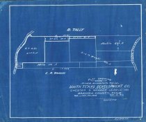
Map Cyanotype Blueprint --------------------------------------------------------------------------------------------- Plat showing land belonging to the South Texas Development Co. out of the Chester S. Gorbet League. Brazoria County, Texas. Scale 1 inch - 500 varas. Oct. 9, 1905. A.J. Wise, Civil Engineer. --------------------------------------------------------------------------------------------- Prominent features: - Brazos River - Oyster Creek Property Owners: - Dix & Wright - South Texas Development Company - Bradley, E.R. - Macklin - Tally, D. - Willis |
Subjects |
Blueprint Brazoria County, Texas Brazos River Chester S. Gorbet league Map Oyster Creek plat South Texas Development Co. survey |
People |
Bass, Nan Bradley, Edward R. Dix Gorbet, Chester S. Macklin Tally, David Willis Wright |
Date |
01/01/1905 |
Dates of Creation |
Start date - 1905, Enddate - 1905 |
Extent of Description |
Paper: 14" wide x 11.5" high Image: 12" wide x 11" high |
Collection |
Nan Bass |
Accession number |
1988.070c |
Other number |
1988-70-52 |
Source |
Nan Bass |
Credit line |
Nan Bass |
Lexicon category |
8: Communication Artifact |
Catalog type |
Map |
Condition |
Fair |
Imagefile |
007\1988.070c.0052.JPG |
Number of images |
1 |