
Archive Record
Images
Metadata
Object Name |
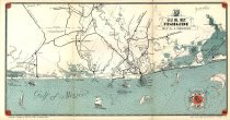
Map |
Catalog Number |
2010.019c.0001 |
Title |
Map -Gulf Oil Corp FISHGUIDE - Freeport |
Search Terms |
Bastrop Bay Bastrop Bayou Big Slough Boggy Bayou Brazoria Brazos River Caney Creek Cedar Lake Creek Cedar Lakes Chocolate Bay Christmas Bay Chubb Lake Churchill Clute Coast Guard station Cold Pass Cow Trap Lake Cox Lake CR227 CR257 CR306 CR310 CR316 CR332 Demi-John Drum Bay Fishguide Fishing FM2918 FM457 FM521 FM523 FM534 Follett's Island Freeport Galveston Bay Gulf Marine Station Gulf of Mexico Gulf Oil Corp Hinkels Ferry Hoskins Junction Hoskins Mound Gulf Intracoastal Waterway Lake Jackson Matagorda Bay McNeal Lake Missouri Pacific Railroad Mud Island Oyster Creek Oyster Lake Pelican Lake Salt Lake San Bernard River San Luis Island San Luis Pass Sargent SH288 SH288 SH36 Swan Lake Titlum Tatlum Bayou Union Pacific Railroad Velasco |
Scope & Content |
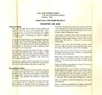
Map -Gulf Oil Corp FISHGUIDE - Freeport RECTO: Gulf Oil Corp FishGuide Map No. 6 Freeport Gulf Coast from Matagorda Bay to San Luis Pass Two-color lithograph on paper VERSO: Explanation and Guide ------------ RECTO: TRANSCRIPT of TITLE BLOCK ------------ GULF OIL CORP. FISHGUIDE MAP NO. 6 FREEPORT Information compiled for Gulf Oil Corp., by Ronnie Luster Not to be used for Navigation Purposes ------------------------------------------------------------------------------- North arrow: compass rose (Gulf Oil Co. Logo) North direction: top of map clockwise approx 49 degrees Compass bearings: no Scale: Unknown ------------ VERSO: TRANSCRIPT of TITLE BLOCK ------------ From: Gulf Fishguide Bureau 11th Floor, Gulf Building Addition Houston, Texas Freeport Area - (Gulf Fishguide Map No. 6) Explanation and Guild ------------------------------------------------------------------------------- |
Subjects |
Civil: - Brazoria townsite - Churchill townsite - Clute townsite - Demi-John (not labeled) - Follett's Island - Freeport townsite - Gulf Marine Station (now Coast Guard station) - Lake Jackson townsite - Mud Island - San Luis Island - Sargent townsite - Velasco townsite Waterways: - Bastrop Bay - Bastrop Bayou (not labeled) - Big Slough - Boggy Bayou - Brazos River - Caney Creek - Cedar Lake Creek - Cedar Lakes - Chocolate Bay - Christmas Bay (not labeled) - Chubb Lake - Cold Pass - Cow Trap Lake (not labeled) - Cox Lake - Drum Bay - Galveston Bay (not labeled) - Gulf of Mexico - Intracoastal Waterway - Lake Jackson (the lake) - Matagorda Bay - McNeal Lake - Oyster Creek - Oyster Lake - Pelican Lake - Salt Lake - San Bernard River - San Luis Pass - Swan Lake - Titlum Tatlum Bayou Transportation infrastructure: - Churchill Bridge (no longer extant) - CR227 (not labeled) - CR257 (not labeled) - CR306 - CR310 (not labeled) - CR316 (not labeled) - CR332 (not labeled) - FM2918 (not labeled) - FM457 - FM521 - FM523 - FM534 - Hinkels Ferry (bridge no longer extant) - Hoskins Junction - Missouri Pacific Railway (now UPRR) - Missouri Pacific Spur to Hoskins Mound (abandoned) - Missouri Pacific Spur to JLSC (no longer extant) - SH288 - SH288 - SH36 |
People |
Walker, John William |
Date |
1950-1970 |
Dates of Creation |
1950-1979 |
Year Range from |
1950 |
Year Range to |
1970 |
Extent of Description |
Paper: 22" wide x 11.5" high Map on recto: 22.1" wide x 11" high Text on verso: 9" wide x 9" high |
Collection |
John Walker Collection |
Accession number |
2010.019c |
Source |
John William Walker |
Credit line |
John William Walker |
Lexicon category |
8: Communication Artifact |
Catalog date |
2010-08-27 |
Catalog type |
Archive |
Condition |
Fair |
Condition date |
2010-08-18 |
Imagefile |
024\2010.019c.0001.jpg |
Number of images |
3 |
Received date |
Aug 2010 |