
Archive Record
Images
Metadata
Object Name |
Map |
Catalog Number |
2010.019c.0002 |
Title |
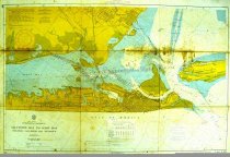
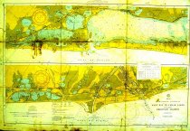
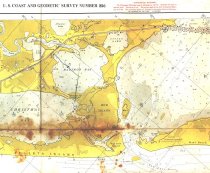
Map - USCGS Nautical Charts 886 and 887 (1955) |
Search Terms |
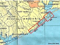
Alligator Lake Auzston Bayou Bastrop Bay Besford Bayou Bolivar Peninsula Brazos River Bryan Lake Bryan Mound Butterowe Bayou Carancahaua Cove Carancahaua Lake Cedar Cut Cedar Lake Creek Cedar Lakes Christmas Bay Cold Pass Cox Lake Dow Barge Canal Drum Bay East Lake Follett's Island Freeport Galveston Galveston Bay Galveston Island Galveston Ship Channel Greens Lake Gulf of Mexico Guyton Cut Hance Bayou Highland Bayou Horseshoe Bend Horseshoe Lake Inner Bar Channel Gulf Intracoastal Waterway Jones Creek Jones Lake Lake Como McNeal Bayou McNeal Lake Mentzell Bayou Metager Cove Mud Pit Nautical Chart Navigation Nicks Lake North Deer Island Oak Bayou Offtatts Bayou Old Brazos River Oyster Lake Pelican Island Pelican Lake Port Bolivar Quintana Redfish Bayou Salt Lake San Bernard River San Luis Pass Snake Island South Deer Island Starvation Cove Staufer Turning Basin Surfside Beach Swan Lake Sweetwater Lake Sydnor Bayou Texas City The Lagoon Titlum Tatlum Bayou Tucker Bayou U.S. Coast & Geodetic Survey USCGS Velasco West Bay Wolf Lake |
Scope & Content |
Map USCGS Nautical Chart (three charts on one sheet) Chart 886: Galveston Bay to West Bay (1955) Chart 887: West Bay to Cedar Lakes (1955) Color lithograph on paper ------------ CHART 886 TRANSCRIPT of TITLE BLOCK ------------ Texas Intracoastal Waterway Galveston Bay to West Bay Including Galveston Bay Entrance Mercator Projection at Lat 29deg 18min Soundings in feet at Mean Low Water 1st Combined Ed. Jan 5/53 Revised 8/29/55 Published at Washington D.C. U. S. Coast & Geodetic Survey H. Arnold Karo, Director Soundings in feet - Scale 1:40,000 C.& G.S. 886 Price 50 cents ---------------------------------------------------------- North arrow: yes North direction: top of map clockwise approx 35 degrees Compass bearings: no Scale: 1:40,000 ------------ CHART 887 TRANSCRIPT of TITLE BLOCK ------------ Texas Intracoastal Waterway West Bay to Cedar Lakes Including Freeport Harbor Mercator Projection at Lat 29deg 01min Soundings in feet at Mean Low Water 1st Combined Ed. Jan 5/53 Revised 8/29/55 ---------------------------------------------------------- Upper map: North arrow: yes North direction: top of map clockwise approx 40 degrees Compass bearings: no Scale: 1:40,000 Lower map: North arrow: yes North direction: top of map clockwise approx 30 degrees Compass bearings: no Scale: 1:40,000 |
Subjects |
Civil: - Bryan Mound - Freeport - Galveston - Port Bolivar - Quintana - Surfside Beach - Texas City - Velasco Islands/Peninsula: - Bolivar Peninsula - Follett's Island - Galveston Island - North Deer Island - Pelican Island - Snake Island - South Deer Island Waterways - Alligator Lake - Auzston Bayou - Bastrop Bay - Besford Bayou - Brazos River - Bryan Lake - Butterowe Bayou - Carancahaua Cove - Carancahaua Lake - Cedar Cut - Cedar Lake Creek - Cedar Lakes - Christmas Bay - Cold Pass - Cox Lake - Dow Barge Canal - Drum Bay - East Lake - Galveston Bay - Galveston Ship Channel - Greens Lake - Gulf of Mexico - Guyton Cut - Hance Bayou - Highland Bayou - Horseshoe Bend - Horseshoe Lake - Inner Bar Channel - Intracoastal Waterway - Jones Creek - Jones Lake - Lake Como - McNeal Bayou - McNeal Lake - Mentzell Bayou - Metager Cove - Mud Pit - Nicks Lake - Oak Bayou - Offtatts Bayou - Old Brazos River - Oyster Lake - Pelican Lake - Redfish Bayou - Salt Lake - San Bernard River - San Luis Pass - Starvation Cove - Staufer Turning Basin - Swan Lake - Sweetwater Lake - Sydnor Bayou - The Lagoon - Titlum Tatlum Bayou - Tucker Bayou - West Bay - Wolf Lake |
People |
Karo, H. Arnold Walker, John William |
Date |
1955 |
Dates of Creation |
1955 |
Year Range from |
1955 |
Year Range to |
1955 |
Extent of Description |
Paper: 38" wide x 27" high Image: 36" wide x 25" high |
Collection |
John Walker Collection |
Accession number |
2010.019c |
Other number |
USCGS 886+887 |
Source |
John William Walker |
Credit line |
John William Walker |
Lexicon category |
8: Communication Artifact |
Catalog date |
2010-08-27 |
Catalog type |
Archive |
Condition |
Fair |
Condition date |
2010-08-18 |
Imagefile |
024\2010.019c.0002-1.jpg |
Number of images |
4 |
Classification |
Documentary Artifact |
Received date |
Aug 2010 |