
Archive Record
Images
Metadata
Object Name |
Map |
Catalog Number |
2009.026c.0003 |
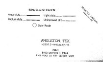
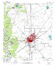
Title |
Map - 1974 USGS 7.5-minute map - Angleton, Texas quadrangle |
Search Terms |
Anchor Angleton Angleton Quadrangle Brushy Bayou Chenango Chenango Lake Clemens State Prison Farm Clemens Unit CR171 CR213 CR233 CR290 CR30 CR32 CR341 CR428 CR45 CR48 CR543 CR588 CR589 Dane Lake FM521 FM523 Jamison Lake Kelly Lake Lewis Lake Missouri Pacific Railroad Mulberry St. Old Airline Highway Old Dingleberry Road Oyster Creek Sally Lake Scoby Lake SH288 SH288B SH35 Styles Bayou Texas Department of Criminal Justice Tigney-Farrer Reservoir Topographic Map U. S. Geological Survey Union Pacific Railroad USGS Van Pelt Wilkins St. |
Scope & Content |
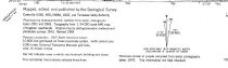
Map 1974 USGS 7.5-minute map Two copies of same map designated (a) and (b) Angleton, Texas quadrangle Printed in color on paper North arrow: yes North direction: top of map Compass bearings: no Scale: 1:24,000 Civil: - Anchor - Angleton - Chenango - Van Pelt Major waterways: - Brushy Bayou - Chenango Lake - Dane Lake - Jamison Lake - Kelly Lake - Lewis Lake - Oyster Creek - Sally Lake - Scoby Lake - Styles Bayou - Tigney-Farrer Reservoir Major transportation infrastructure: - CR 341 (not labeled) - CR171 (not labeled) - CR213 (not labeled) - CR290 (not labeled) - CR30 (not labeled) - CR32 (not labeled) - CR428 (not labeled) - CR45 (not labeled) - CR48 (not labeled) - CR588 (not labeled) - CR589 - Dingleberry Road (now CR233) - FM521 - FM523 (now CR428 and CR543) - Missouri Pacific Railway (now UPRR; no longer extant northwest of Angleton) - Mulberry St. - Old Airline Highway (now CR48) - SH288 (now SH288B) - SH35 - Wilkins St. Highways now designated SH288 and FM523 are not shown. |
Subjects |
Anchor Angleton Angleton Quadrangle Brushy Bayou Chenango Chenango Lake Clemens State Prison Farm Clemens Unit CR171 CR213 CR233 CR290 CR30 CR32 CR341 CR428 CR45 CR48 CR543 CR588 CR589 Dane Lake FM521 FM523 Jamison Lake Kelly Lake Lewis Lake Missouri Pacific Railway Mulberry St. Old Airline Highway Old Dingleberry Road Oyster Creek Sally Lake Scoby Lake SH288 SH288B SH35 Styles Bayou Texas Department of Criminal Justice Tigney-Farrer Reservoir Topographic Map U. S. Geological Survey Union Pacific Railroad UPRR USGS Van Pelt Wilkins St. |
Date |
1974 |
Dates of Creation |
1963; Photorevised 1974 |
Year Range from |
1963 |
Year Range to |
1974 |
Extent of Description |
23" wide x 27" high |
Collection |
Transfer from Library Collection |
Accession number |
2009.026c |
Old ID number |
Library 2005.06.01 |
Source |
Transfer from Library Collection |
Lexicon category |
8: Communication Artifact |
Catalog date |
2009-04-07 |
Catalog type |
Archive |
Imagefile |
023\2009.026c.0003-01.JPG |
Number of images |
4 |
Relation |
Show Related Records... |