
Archive Record
Images

Metadata
Object Name |
Map |
Catalog Number |
2008.010c.0009 |
Title |
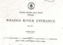
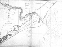
Map - U.S.C. & G.S. Map Mouth of Brazos River |
Search Terms |
Brazos River Brazos River Light Brazosport Freeport Galveston and Brazos Canal Gulf of Mexico Houston and Brazos Valley Railway Gulf Intracoastal Waterway Jupiter Cut Lake Bryan Oyster Creek Quintana Texas Coast U. S. Coast Survey Velasco West Union Bayou |
Scope & Content |
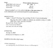
Map Printed black ink on translucent paper U.S.C. & G.S. Map - Mouth of Brazos River -------------------------------------------------------------------------------------------- United States - Gulf Coast - Texas Brazos River Entrance Scale 1/10000 Published at Washington, D.C., July 1917 By the U. S. Coast and Geodetic Survey E. Lester-Jones, Superintendent -------------------------------------------------------------------------------------------- North arrow: yes North direction: top of map Compass bearings: no Scale: 1:10000 Scale unit: linear Prominent features:- Brazos River - Brazos River Light - Brazosport (the original community of) - Freeport - Galveston and Brazos Canal - Gulf of Mexico - Houston & Brazos Valley Railroad - Jupiter Cut - Lake Bryan - Oyster Creek - Quintana - Shoreline - Velasco - West Union Bayou |
Subjects |
Brazos River Brazos River Light Brazosport Freeport Galveston and Brazos Canal Gulf of Mexico Houston & Brazos Valley Railroad Intracoastal Waterway Jupiter Cut Lake Bryan Oyster Creek Quintana Texas Coast U. S. Coast Survey Velasco West Union Bayou |
People |
Lester-Jones, E. |
Date |
July 1917 |
Dates of Creation |
July 1917 |
Year Range from |
1917 |
Year Range to |
1917 |
Extent of Description |
Paper: 41" wide x 30" high Image: 39" wide x 28" high |
Collection |
U. S. Coast & Geodetic Survey of Texas Coast |
Accession number |
2008.010c |
Source |
BCHM |
Credit line |
BCHM |
Lexicon category |
8: Communication Artifact |
Catalog date |
2008-03-25 |
Catalog type |
Archive |
Imagefile |
021\2008.010c.0009-1.jpg |
Number of images |
4 |