
Archive Record
Images
Metadata
Object Name |
Map |
Catalog Number |
2009.003c.0001 |
Title |
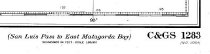
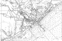
Map - USCGS Nautical Chart 1283 - San Luis Pass East Matagorda Bay |
Search Terms |
Bastrop Bay Bastrop Bayou Big Boggy National Wildlife Refuge Big Slough Boggy Bayou Brazoria Brazoria National Wildlife Refuge Brazos River Brazosport Bryan Beach Bryan Mound Canoe Creek Cedar Lake Bayou Cedar Lake Creek Cedar Lakes Christmas Bay Chubb Lake Churchill Coast & Geodetic Survey Cox Lake Demi-John Island Department of Commerce East Matagorda Bay East Union Bayou Flag Lake FM 2611 FM 521 Follets Island Freeport Freeport Harbor Fresh Water Lake Galveston Gulf of Mexico Gulf Park Horseshoe Lake Hoskins Junction Hoskins Mound Gulf Intracoastal Waterway Jetties Jones Creek Lake Austin Lake Barbara Lake Jackson Live Oak Bayou Matagorda Bay Matagorda Peninsula Mims Missouri Pacific Railroad Moodys Island MPR National Ocean Survey National Oceanic & Atmospheric Administration NOAA Oyster Creek Pelton Lake Percy Landing Quintana Round Lake San Bernard National Wildlife Refuge San Bernard River San Luis Pass Sargent State Highway 332 Stratton Ridge Stubblefield Lake Surfside Beach Swan Lake Union Pacific Railroad Velasco Velasco Heights |
Scope & Content |
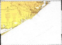
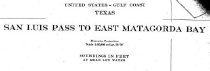
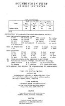
Map Printed in color on paper Map - USCGS Nautical Chart 1283 - San Luis Pass East Matagorda Bay ----------------- TRANSCRIPT OF TITLE BLOCKS ------------------------ United States - Gulf Coast, Texas San Luis Pass to East Matagorda Bay Mercator projection Scale 1:80,000 at Lat. 28 deg 50 min Soundings in Feet at Mean Low Water HEIGHTS: Heights in feed above Mean High Water AUTHORITIES: Hydrography and topography by the National Ocean Survey (Formerly the Coast and Geodetic Survey) with additional data from The Corps of Engineers and the U.S. Coast Guard Published at Washington, D.C. U. S. Department of Commerce National Oceanic & Atmospheric Administration National Ocean Survey C&GS 1283 Soundings in feet - Scale 1:80,000 ----------------------------------------------------------------------------------------------- North arrow: yes North direction: top of map Compass bearings: no Scale: 1:80,000 Prominent Features: - Bastrop Bay - Bastrop Bayou - Big Slough - Boggy Bayou - Brazoria - Brazos River - Bryan Beach - Bryan Mound - Canoe Creek - Cedar Lake Bayou (now Cedar Lake Creek) - Cedar Lakes - Christmas Bay (formerly Oyster Bay) - Chubb Lake - Churchill - Cox Lake - Demi-John Island (not labeled) - Depth soundings - East Matagorda Bay - East Union Bayou - Flag Lake - FM 2611 (not labeled) - FM 521 (not labeled) - Follets Island - Freeport - Freeport Harbor - Fresh Water Lake - Galveston - Gulf of Mexico - Gulf Park - Horseshoe Lake - Hoskins Junction - Intracoastal Waterway - Jetties - Jones Creek - Lake Austin - Lake Barbara - Lake Jackson - Live Oak Bayou - Matagorda Bay - Matagorda Peninsula - Mims - Missouri Pacific Railroad (now UPRR) - Moodys Island - Oyster Creek - Pelton Lake - Percy Landing - Quintana (not labeled) - Round Lake - San Bernard River - San Luis Pass - Sargent - State Highway 332 - Stratton Ridge - Stubblefield Lake - Surfside Beach - Swan Lake - Velasco - Velasco Heights |
Subjects |
- Bastrop Bay - Bastrop Bayou - Big Slough - Boggy Bayou - Brazoria - Brazos River - Bryan Beach - Bryan Mound - Canoe Creek - Cedar Lake Bayou (now Cedar Lake Creek) - Cedar Lakes - Christmas Bay (formerly Oyster Bay) - Chubb Lake - Churchill - Cox Lake - Demi-John Island (not labeled) - Depth soundings - East Matagorda Bay - East Union Bayou - Flag Lake - FM 2611 (not labeled) - FM 521 (not labeled) - Follets Island - Freeport - Freeport Harbor - Fresh Water Lake - Galveston - Gulf of Mexico - Gulf Park - Horseshoe Lake - Hoskins Junction - Intracoastal Waterway - Jetties - Jones Creek - Lake Austin - Lake Barbara - Lake Jackson - Live Oak Bayou - Matagorda Bay - Matagorda Peninsula - Mims - Missouri Pacific Railroad (now UPRR) - Moodys Island - Oyster Creek - Pelton Lake - Percy Landing - Quintana (not labeled) - Round Lake - San Bernard River - San Luis Pass - Sargent - State Highway 332 - Stratton Ridge - Stubblefield Lake - Surfside Beach - Swan Lake - Velasco - Velasco Heights |
Date |
12/15/1973 |
Dates of Creation |
12/15/1973 |
Year Range from |
1973 |
Year Range to |
1973 |
Extent of Description |
Paper: 46" wide x 35" high Image: 44" wide x 34" high |
Collection |
BCHM |
Accession number |
2009.003c |
Source |
Museum Purchase |
Lexicon category |
8: Communication Artifact |
Catalog date |
2009-01-30 |
Catalog type |
Archive |
Imagefile |
022\2009.003c.0001-00.jpg |
Number of images |
5 |