Skip to content

Search Term Record

Metadata

Related Records

  1. Map - 1988.070c.0086

    Map - Texas Land and Sugar Company Plantations

    Record Type: Archive

    1988.070c.0086  Title Block
  2. Map - 1988.070c.0108

    Map - Hinkle's Ferry and Vicinity in T.B.Bell League

    Record Type: Archive

    Map - Hinkle's Ferry and Vicinity in T.B.Bell League
  3. Map - 2009.003c.0001

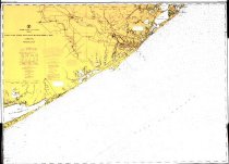
    Map - USCGS Nautical Chart 1283 - San Luis Pass East Matagorda Bay

    Record Type: Archive

    2009.003c.0001  Entire Kap
  4. Map - 2009.026c.0010

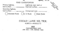
    Map - 1972 USGS 7.5-minute map - Cedar Lane NE, Texas quadrangle

    Record Type: Archive

    2009.026c.0010  Title Block

Thank You!

Confirmation Message Here....