Skip to content

Person Record

Metadata

Related Records

  1. Blueprint - 1984.021c.0007

    Map - Damon Mound Oil Field

    Record Type: Archive

    1984.021c.0007   Title Block
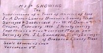
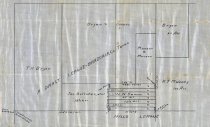
  2. Map - 1988.070c.0065

    Map - subdivisions of a tract of 12.5 acres of land in Abraham Darst league

    Record Type: Archive

    1988.070c.0065  Title Block
  3. Map - 1988.070c.0147

    Map - Damon Mound subdivisions of

    Record Type: Archive

    1988.070c.0147  Title Block
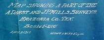
  4. Map - 1988.070c.0150

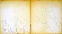
    Map - Subdivisions of Abraham Darst and John P. Mills Surveys

    Record Type: Archive

    1988.070c.0150  Title Block
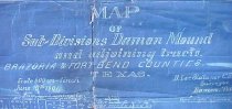
  5. Map - 1988.070c.0154

    Map - Subdivisions of lands located in the Abraham Darst league west of Community of Damon.

    Record Type: Archive

    1988.070c.0154  Entire Map
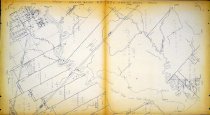
  6. Map - 2009.024c.0012

    Map - Damon USGS quadrangle - Title Services Inc. Plat Map

    Record Type: Archive

    2009.024c.0012  North half of quad
  7. Map - 2009.024c.0018

    Map - Guy USGS quadrangle - Title Services Inc. Plat Map

    Record Type: Archive

    2009.024c.0018  North half of quad
  8. Map - 2009.024c.0020

    Map - Hoskins Mound USGS quadrangle - Title Services Inc. Plat Map

    Record Type: Archive

    2009.024c.0020 North Half

Thank You!

Confirmation Message Here....