
Archive Record
Images

Metadata
Object Name |
Map |
Catalog Number |
2009.024c.0018 |
Title |
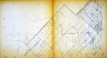
Map - Guy USGS quadrangle - Title Services Inc. Plat Map |
Search Terms |
Cedar Creek CR 10 CR 4 Damon Mound (west half, not labeled) Fort Bend County Line Guy USGS quadrangle Mound Creek San Bernard River Texas and New Orleans Railroad) Title Services Inc. Wharton County Line |
Scope & Content |
Map Title Services Inc. Plat Map Guy USGS quadrangle Diazotype Whiteprint in two sheets designated 2009.024c.0018-N 2009.024c.0018-S ABSTRACTS - see NOTES North arrow: no North direction: top of map Compass bearings: no Scale: 1:12,000 CIVIL: - Damon Mound (west half, not labeled) - Fort Bend County Line - Wharton County Line ORIGINAL GRANTEES: - Darst, Abraham - McNeel, P.D. - Prater, William - Robbins, William TRANSPORTATION INFRASTRUCTURE - CR 10 - CR 4 - Texas and New Orleans Railroad ROW (now CR 10) WATERWAYS - Cedar Creek - Mound Creek - San Bernard River |
Subjects |
Cedar Creek CR 10 CR 4 Damon Mound (west half, not labeled) Fort Bend County Line Guy USGS quadrangle Mound Creek San Bernard River Texas and New Orleans Railroad) Title Services Inc. Wharton County Line |
People |
Darst, Abraham McNeel, Pleasant D. Prater, William Robbins, William Tyson, Dick |
Date |
1978 |
Dates of Creation |
1978 |
Year Range from |
1978 |
Year Range to |
1978 |
Extent of Description |
Paper: 44" wide x 24" high Image: 42" wide x 24" high |
Collection |
White Collection |
Accession number |
2009.024c |
Old ID number |
1C |
Other number |
Guy Quadrangle |
Source |
Dick Tyson |
Credit line |
Dick Tyson |
Lexicon category |
8: Communication Artifact |
Catalog date |
2010-03-19 |
Catalog type |
Archive |
Imagefile |
023\2009.024c.0018-N.jpg |
Number of images |
3 |
Received date |
Aug. 2008 |