
Archive Record
Images
Metadata
Object Name |
Map |
Catalog Number |
2012.001c.0003 |
Title |
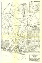
Map - Freeport Harbor, roads, railroads |
Search Terms |
Angleton Brazoria Brazos River Christmas Bay Clute Drum Bay East Union Bayou Freeport Freeport Harbor Gulf of Mexico Hoskins Mounds Houston and Brazos Valley Railway International & Great Northern Railroad Gulf Intracoastal Waterway Jefferson Lake Sulphur Co Jones Creek Lake Jackson McNeal Lake Missouri Pacific Railroad Oyster Bay Oyster Creek Pelican Lake Salt Lake San Bernard River Scoby Lake SH288 (now SH288B) SH35 SH36 St. Louis, Brownsville and Mexico Railway Swan Lake Turning basins U.S Corps Engineer Office Union Pacific Railroad Velasco West Columbia |
Scope & Content |
Map - Freeport Harbor, roads, railroads Index to 7.5-minute USGS maps Printed black ink on paper Originally folded 3x3 for distribution ------------------- TRANSCRIPT OF TITLE BLOCK ---------------------- Freeport Harbor Texas Index Map Scale of Miles U.S Engineer Office ~ Galveston, Texas ~ Feb 1848 To accompany Review of Reports Dated February 27, 1948 File: BRAZ 501-188 Plate 1 91239 O-49 (inside back cover) No. 1 ------------------------------------------------------------------------------------------ North arrow: yes North direction: top of map clockwise 40 deg. Compass bearings: no Lat/Long: yes Lat/Long interval: 7' 30" Scale Unit: Miles Scale: Graphic (scales at approx 1" = 2 miles Civil: - Angleton - Brazoria - Clute - Freeport - Jones Creek - Lake Jackson - Oyster Creek - Velasco - West Columbia Roads - SH288 (now SH288B) - SH35 - SH36 - Unidentified county roads Railroads: - Missouri Pacific (formerly Houston and Brazos Valley Railway; now UPRR) - Missouri Pacific (formerly International & Great Northern Railroad (no longer extant) - Missouri Pacific (formerly St. Louis, Brownsville & Mexico Railway; now UPRR) - Missouri Pacific Hoskins Mounds spur (no longer extant) - Missouri Pacific Jefferson Lake Sulphur Co. spur (no longer extant) - Unidentified rail line paralleling Brazos River between Freeport and the southern shore of Lake Jackson (the lake) (no longer extant) Waterways: - Brazos River - Drum Bay - East Union Bayou - Gulf of Mexico - Intracoastal Waterway - Jones Creek - Lake Jackson (the lake) - McNeal Lake - Oyster Bay (now Christmas Bay) - Oyster Creek - Pelican Lake - Salt Lake - San Bernard River - Scoby Lake - Swan Lake - Turning basins |
People |
Davis, A.B. Jr. Dillingham, M.A. Norman, R.H. Robinson, B.L. |
Date |
February 1948 |
Dates of Creation |
February 1948 |
Extent of Description |
13.3" wide x 21" high |
Collection |
Found in Collection |
Accession number |
2012.001c |
Other number |
Braz 501-188 Plate 1 |
Source |
Found in Collection |
Lexicon category |
8: Communication Artifact |
Catalog date |
2012-04-30 |
Catalog type |
Archive |
Imagefile |
028\2012001c0003.JPG |
Number of images |
1 |