
Archive Record
Images
Metadata
Object Name |
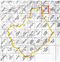
Map |
Catalog Number |
2009.026c.0017 |
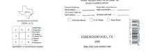
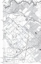
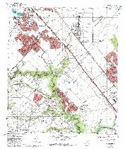
Title |
Map - 1995 USGS 7.5-minute map - Friendswood, Texas quadrangle |
Search Terms |
Clover (Oil) Field Cowart Creek Dixie Farm Road FM2351 FM518 Friendswood Galveston County (partial) Harris County (partial) Hastings Hastings Oil Field Landing Strip Marys Creek Meadow Lane Pearland Pines St. Rustic Lane SH35 Topographic Map US Geological Survey USGS Westfield Road |
Scope & Content |
Map 1995 USGS 7.5-minute map Friendswood, Texas quadrangle North arrow: yes North direction: top of map Compass bearings: no Scale: 1:24,000 Civil: - Clear Lake City - Galveston County (partial) - Harris County (partial) - Pearland - Clover (Oil) Field - Hastings - Hastings Oil Field - League City Major waterways: - Chigger Creek - Clear Creek - Cowart Creek - Marys Creek -Turkey Creek Major transportation infrastructure: - Dixie Farm Road - FM2351 - FM518 - Landing Strip - Meadow Lane - Pines St. - Rustic Lane - SH35 - Westfield Road |
Subjects |
Clover (Oil) Field Cowart Creek Dixie Farm Road FM2351 FM518 Friendswood Galveston County (partial) Harris County (partial) Hastings Hastings Oil Field Landing Strip Marys Creek Meadow Lane Pearland Pines St. Rustic Lane SH35 Topographic Map US Geological Survey USGS Westfield Road |
Date |
1995 |
Dates of Creation |
1995 |
Year Range from |
1995 |
Year Range to |
1995 |
Extent of Description |
23" wide x 27" high |
Collection |
Transfer from Library Collection |
Accession number |
2009.026c |
Old ID number |
2005.06.01 |
Source |
Transfer from Library Collection |
Lexicon category |
8: Communication Artifact |
Catalog date |
2009-07-17 |
Catalog type |
Archive |
Imagefile |
023\2009.026c.0017-01.jpg |
Number of images |
5 |