
Archive Record
Images
Metadata
Object Name |
Map |
Catalog Number |
2010.031c.0008 |
Title |
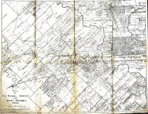
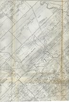
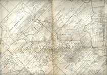
Map - Old Ocean, Sweeny, and West Columbia Areas |
Search Terms |
Allenhurst Bay City Black Ferry Road Bells Creek Brazoria McNeel Cedar Lake Road Brazos River CR25 CR316 CR321 CR353 CR356 CR359 CR376 East Columbia Findley Road Flag Pond FM1301 FM145 FM1459 FM424 FM521 FM522 FM524 Four Forks Sweeny Road Hasima Hollandia International & Great Northern Railroad Linville, Bayou Little Linville Bayou Lone Star Water Co. Canal Middle Bayou Old Ocean (the wetland) Phillips Oil Co. San Bernard River SH35 SH36 SH58 St. Louis, Brownsville and Mexico Railway Superior Oil Co. Sweeny Sweeny Columbia Road U.S. Oil Co. Varner Creek West Columbia West Columbia Cedar Brake Road Wild Peach |
Scope & Content |
Map - Old Ocean, Sweeny, and West Columbia Areas Eight Xerographic photo copies taped together Folded 2x4 Appears to be a photocopy of a plat map of portions of Brazoria and Matagorda Counties indicating oil or gas wells. The original plat map appears to have been cut from copies of two even older plat maps and overwritten with handwritten notations indicating locations of additional oil or gas wells. North arrow: no North direction: top of map approximately Compass bearings: no Scale: 1" = 1000 varas approximately Scale unit: vara -------------------- TRANSCRIPT OF TITLE BLOCK ------------------ Map of Old Ocean, Sweeny, and West Columbia Areas Scale 1000 vs. = 1 inch Brazoria County Abstract Co. Angleton, Texas ------------------------------------------------------------------ Prominent features: - Canals - Dirt or shell roads - Oil/gas wells - Original grant boundaries - Original grantee names - Pipelines - Principal communities indicated by graphic symbol - Property owner names - Railroad junctions - Railroads - Shell roads - State highways - Subdivision Boundaries - Waterways Civil: - Allenhurst townsite (Matagorda County) - East Columbia - Hasima townsite - Sweeny - West Columbia - Wild Peach S/D Grantees named on map: - Austin, Stephen F. - Austin, Stephen F. 7+1/3 leagues - Battle, M.M., Berry, M. & Williams, J. - Bell, Josiah - Breen, Charles - Cummings, James - Cummings, Rebecca - Foster, Isaac - Franklin, B.C. - George Freeman - Harrison, George - Johnson Borden & Walker - Jones, Oliver - Keep, Imla - McCormick, David - McNeel, Daniel - Mimms, Joseph - Nuckles, M.B. - Perry, J.F. & Austin F.M. - Pettus Freeman - Phillips, Zeno - Polly & Chance - Sojouner - White, Joseph - Williams, R.H. - Williams, S.M. Transportation Infrastructure - Bay City Black Ferry Road (now CR359) - Brazoria McNeel Cedar Lake Road (now FM521) - CR25 (not labeled) - CR316 (not labeled) - CR321 (not labeled) - CR353 (not labeled) - CR356 (not labeled) - CR376 (not labeled) - Findley Road (Matagorda County; not labeled) - FM424 (not labeled) - FM522 (not labeled) - Four Forks Sweeny Road (now FM524) - IGNRW (no longer extant) - International & Great Northern Railway (no longer extant) - Old Railroad Grade to Wharton - SH35 (not labeled) - SH36 (not labeled) - SH58 (now SH35 west of FM1459) - SLBMR - St. Louis Brownsville & Mexico Railway - Sweeny Columbia Road (now FM1459) - West Columbia Cedar Brake Road (now FM1301) Waterways - Bells Creek - Brazos River - Flag Pond - Linville, Bayou - Little Linville Bayou (not labeled) - Lone Star Water Co. Canal - Middle Bayou - Old Ocean (the wetland) - San Bernard River - Varner Creek (not labeled) Overprint notations: - 118 Ac Phillips Oil Co. - Hollandia Approx Depth 10162' Drilled - Superior Oil Co. H.P. Gas Distillate - U.S. Oil Co. John Mecom |
Subjects |
Civil: - Allenhurst townsite (Matagorda County) - East Columbia - Hasima townsite - Sweeny - West Columbia - Wild Peach S/D Grantees named on map: - Austin, Stephen F. - Austin, Stephen F. 7+1/3 leagues - Battle, M.M., Berry, M. & Williams, J. - Bell, Josiah - Breen, Charles - Cummings, James - Cummings, Rebecca - Foster, Isaac - Franklin, B.C. - George Freeman - Harrison, George - Johnson Borden & Walker - Jones, Oliver - Keep, Imla - McCormick, David - McNeel, Daniel - Mimms, Joseph - Nuckles, M.B. - Perry, J.F. & Austin F.M. - Pettus Freeman - Phillips, Zeno - Polly & Chance - Sojouner - White, Joseph - Williams, R.H. - Williams, S.M. Transportation Infrastructure - Bay City Black Ferry Road (now CR359) - Brazoria McNeel Cedar Lake Road (now FM521) - CR25 (not labeled) - CR316 (not labeled) - CR321 (not labeled) - CR353 (not labeled) - CR356 (not labeled) - CR376 (not labeled) - Findley Road (Matagorda County; not labeled) - FM424 (not labeled) - FM522 (not labeled) - Four Forks Sweeny Road (now FM524) - IGNRW (no longer extant) - International & Great Northern Railway (no longer extant) - Old Railroad Grade to Wharton - SH35 (not labeled) - SH36 (not labeled) - SH58 (now SH35 west of FM1459) - SLBMR - St. Louis Brownsville & Mexico Railway - Sweeny Columbia Road (now FM1459) - West Columbia Cedar Brake Road (now FM1301) Waterways - Bells Creek - Brazos River - Flag Pond - Linville, Bayou - Little Linville Bayou (not labeled) - Lone Star Water Co. Canal - Middle Bayou - Old Ocean (the wetland) - San Bernard River - Varner Creek (not labeled) Overprint notations: - 118 Ac Phillips Oil Co. - Hollandia Approx Depth 10162' Drilled - Superior Oil Co. H.P. Gas Distillate - U.S. Oil Co. John Mecom |
People |
Austin, F.M. Battle, Miles M. Bell, Josiah Hughes Berry, M. Breen, Charles Cummings, James Cummings, Rebecca Foster, Isaac Franklin, Benjamin Cromwell Freeman, George Harrison, George Jones, Oliver McCormick, David McNeel, Daniel Mecom, John Mims, Joseph Nuckols, M.B. Perry, James Franklin Freeman, Pettus Phillips, Zeno White, Joseph Williams, J. Williams, Robert H. Williams, S.M. |
Year Range from |
1920 |
Year Range to |
1950 |
Extent of Description |
Paper: 32" wide x 25.5" high Image: 31" wide x 24.5" high |
Collection |
BCHM |
Accession number |
2010.031c |
Source |
Transfer from BCHM Library File |
Lexicon category |
8: Communication Artifact |
Catalog date |
2011-01-07 |
Catalog type |
Archive |
Imagefile |
024\2010.031c.0008.jpg |
Number of images |
3 |