
Archive Record
Images
Metadata
Object Name |
Map |
Catalog Number |
2009.017c.0001 |
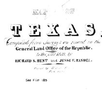
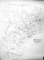
Title |
Map - East half of Texas plus portions of Arkansas and Louisiana- 1839 |
Search Terms |
Austin, Texas Austin Small Colony Bastrop Beaumont Bolivar Peninsula Brazoria Brazos River Colorado River Columbia Columbus Fannin (battle site) Fort Houston Galveston General Land Office Goliad Gonzales Guadalupe River Gulf of Mexico Houston Laguna de Madre Laredo Liberty Liverpool Llano River Matagorda Island Matamoros Mexico Montgomery Nacogdoches Nueces River Padre Island Parker's Fort Port Isabel Presidio Road Quintana Red River Republic of Texas Richmond Rio Brazos de Dios Rio Neches Rio San Bernard Rio San Marcos Rio San Miguel Sabine River Saline River San Antonio de Bexar San Augustin San Felipe de Austin San Luis Pass San Patricio Shreveport LA Small Colony Texana Velasco Victoria Waco Villa West Columbia West Pass Washington-on-the-Brazos |
Scope & Content |
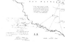
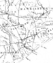
Map East half of Texas plus portions of Arkansas and Louisiana Diazotype whiteprint ------------------ TRANSCRIPT OF TITLE BLOCK ------------------------- Map of Texas Compiled from Surveys on record in the General Land Office of the Republic In the year 1839 by Richard S. Hunt and Jesse F. Randel Copied by (illegible) See Film 185 ------------------------------------------------------------------------------------------- North arrow: no North direction: top of map Compass bearings: no Scale: Graphic Scale unit: N/A Civil: - Austin Small Colony - Austin, City of - Bastrop - Beaumont - Bolivar Peninsula - Brazoria - Columbia (now West Columbia) - Columbus - Fannin's Battle - Fort Houston - Galveston - Goliad - Gonzales - Houston - Laguna de Madre - Laredo - Liberty - Liverpool - Matagorda Island - Matamoros Mexico - Montgomery - Nacogdoches - Padre Island - Parker's Fort - Port Isabel - Presidio Road - Quintana - Richmond - Road from San Antonio de Bexar to Nacogdoches - San Antonio de Bexar - San Augustin - San Felipe de Austin - San Patricio - Shreveport LA - Texana - Velasco - Victoria - Waco Villa - Washington (on the Brazos) Waterways: - Brazos River - Colorado River - Guadalupe River - Gulf of Mexico - Gulf of Mexico - Laguna de Madre - Llano River - Nueces River - Red River - Rio Brazos de Dios - Rio Neches - Rio San Bernard - Rio San Marcos - Rio San Miguel - Sabine River - Saline River - West Pass (now San Luis Pass) |
Subjects |
Austin (city of) Austin Small Colony Bastrop Beaumont Bolivar Peninsula Brazoria Brazos River Colorado River Columbia Columbus Fannin (battle site) Fort Houston Galveston General Land Office Goliad Gonzales Guadalupe River Gulf of Mexico Houston Laguna de Madre Laredo Liberty Liverpool Llano River Matagorda Island Matamoros Mexico Montgomery Nacogdoches Nueces River Padre Island Parker's Fort Port Isabel Presidio Road Quintana Red River Republic of Texas Richmond Rio Brazos de Dios Rio Neches Rio San Bernard Rio San Marcos Rio San Miguel Sabine River Saline River San Antonio de Bexar San Augustin San Felipe de Austin San Luis Pass San Patricio Shreveport LA Small Colony Texana Velasco Victoria Waco Villa Washington on the Brazos West Columbia West Pass |
People |
Hunt, Richard S. Randel, Jesse F. |
Date |
1839 |
Dates of Creation |
1839 |
Year Range from |
1839 |
Year Range to |
1839 |
Extent of Description |
Paper: 25" wide x 33" high Image: 23" wide x 31" high |
Collection |
Transfer from Library Collection |
Accession number |
2009.017c |
Old ID number |
Reference 96.96.01 |
Source |
Transfer from Library Reference File |
Lexicon category |
8: Communication Artifact |
Catalog date |
2009-05-12 |
Catalog type |
Archive |
Imagefile |
023\2009.017c.0001-1.jpg |
Number of images |
4 |