
Archive Record
Images
Metadata
Object Name |
Map |
Catalog Number |
2011.025c.0004 |
Title |
Map - Texas DOT highway map - Brazoria County southwest |
Search Terms |
Anchor Junction Anchor Townsite Angleton Armory Bailey's Prairie Chenango Oil Field CR171 CR210 CR243 CR290 CR30 CR31 CR32 CR337 CR339 CR341 CR45 CR513 CR598 CR609 FM325 southwest FM521 International & Great Northern Railroad Missouri Pacific Railroad SH288 SH36 Texas Agricultural Extension Station Texas AgriLife Extension |
Scope & Content |
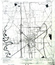
Map 1963 USGS 7.5-minute map Angleton, Texas quadrangle Xerographic photocopy of an overwritten 1963 USGS map This map is a photocopy of a planning map related to the construction of new roadways (SH288 and FM325) and reconstruction of existing roadways. North arrow: yes North direction: top of map Compass bearings: no Scale: 1:24,000 Major transportation infrastructure: - Anchor Junction (no longer extant) - CR243 - CR171 (not labeled) - CR210 - CR290 - CR30 - CR31 - CR32 - CR337 - CR339 - CR341 - CR45 - CR513 - CR598 - CR609 - FM521 - International & Great Northern Railway (no longer extant) - Missouri Pacific Railway (now UPRR) - SH36 Proposed transportation infrastructure changes indicated by overwrite: - SH288 - SH288/SH36 Interchange - SH288/CR44 Interchange - FM325 southwest of SH36 - FM523/CR171 Interchange - FM523/SH35 Interchange Civil: - Anchor Townsite - Angleton - Armory (Now Texas AgriLife Extension) - Bailey's Prairie - Chenango Oil Field - Texas Agricultural Extension Station (no longer extant) |
Date |
1936 |
Dates of Creation |
Base map: 1963 Overwrite: Unknown |
Year Range from |
1936 |
Year Range to |
1936 |
Collection |
Collected by Staff |
Accession number |
2011.025c. |
Source |
Collected by BCHM Staff |
Lexicon category |
8: Communication Artifact |
Catalog date |
2011-08-30 |
Catalog type |
Archive |
Imagefile |
026\2011025c0004-1.JPG |
Number of images |
1 |
Relation |
Show Related Records... |