
Archive Record
Images
Metadata
Object Name |
Map |
Catalog Number |
1988.070c.0012 |
Title |
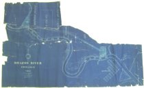
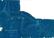
Map - Brazos River entrance |
Search Terms |
Brazos River plat Quintana survey Velasco, Brazos and Northern Railway |
Scope & Content |
Survey map. Cyanotype Blueprint ------------------------------------------------------------------------------------------ BRAZOS RIVER ENTRANCE TEXAS Scale 1:10,000 Drawn by Jno. T. Witt Civil Engineer Surveyor Magnetic Variation 8 degrees 30 minutes East ------------------------------------------------------------------------------------------ North arrow: yes North direction: top of map Apparently drawn on comission by VB&NRR railroad [see notes]. Apperently drawn in connection with the acquisition of two parcels of land by the railroad: 27.0 acres - 200-foot right-of-way 30.0 acres - 1000-foot x 1500-foot parcel abutting existing 7-acre parcel on north side of Brazos River. Prominent features: - Old Brazos River from present-day railroad bridge (Magnolia Street) to mouth of river at Gulf shore. - VB&NRR properties (right-of-way and larger parcels). - Platted streets in Quintana - Properties owned by Mauricio Henry; Mauricio Henry Surv[ivors?], A. Calvit. |
Subjects |
Brazos River plat Quintana survey VB&NRR Railroad Velasco Brazos and Northern Railroad |
People |
Bass, Nan Calvit, A. Henry, Mauricio Witt, T. |
Date |
1904 |
Dates of Creation |
1904 |
Extent of Description |
Paper size: 27.7" wide x 17.0" high Image size: 17.0" wide x 17.0" high |
Collection |
Nan Bass |
Accession number |
1988.070c |
Other number |
1988-70-12 |
Source |
Nan Bass |
Credit line |
Nan Bass |
Lexicon category |
8: Communication Artifact |
Catalog type |
Archive |
Condition |
Fair |
Condition Notes |
Severely torn; portions missing. Repaired and placed within mylar sheets 1/13/2006. |
Condition date |
2006-01-13 |
Imagefile |
007\1988.070c.0012.JPG |
Number of images |
3 |