
Archive Record
Images
Metadata
Object Name |
Map |
Catalog Number |
1989.006c.0033 |
Title |
Maps - 1943 War Department 7.5-minute maps - Angleton and Rosharon quadrangles |
Search Terms |
Airline Road Anchor townsite Angleton Cemetery Angleton townsite Army Corps of Engineers Austin Bayou Bearie Chapel Bonney townsite Chenango Lake Chenango School Chenango siding Chenango townsite China Grove School Collins Lake Cooper School CR171 CR34 CR45 CR48 Daughters Cemetery Flores Bayou FM1462 FM521 Jamison Lake Kelly Lake Lewis Lake Lockridge Road Missouri Pacific Railroad New Revelation Church Old Angleton-Alvin Road Old Houston Angleton Road Oyster Creek Pilgrim Cemetery Ramsey State Farm Revelation Cemetery Revelation Church Rosharon townsite Rosharon-Alvin Road Scoby Lake SH288 Simms Road Styles Bayou Tennessee Valley Authority Texas Agricultural Experimental Station Thrumond Lake Union Pacific Railroad War Department, Ware Lake World War II Zion Church |
Scope & Content |
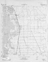
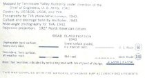
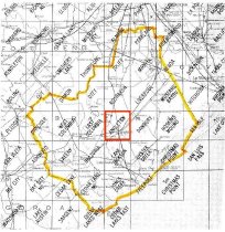
Two Maps 1943 War Department 7.5-minute maps Angleton and Rosharon quadrangles Diazotype whiteprints ------------- 1989.006c.0033a --------------------------------------- War Department, Corps of Engineers, U.S. Army Rosharon Quadrangle, 7 1/2-minute series Rosharon, Tex., N2915-W9522.5/7.5 Contour Interval 5 feet, Datum is mean sea level Mapped by Tennessee Valley Authority under the direction of the Chief of Engineers, U.S. Army ---------------------------------------------------------------------------------------------- North arrow: yes North direction: top of map Compass bearings: no Scale: 1:31,680 Scale unit: miles; yards Prominent Features: - Airline Road (now CR48) - Austin Bayou - Bonney townsite - Chenango Lake - Chenango School - China Grove School - Cooper School - Daughters Cemetery - Flores Bayou - Lockridge Road (now FM1462) - Missouri Pacific Railway (now UPRR) - Old Houston Angleton Road (now FM521) - Pilgrim Cemetery - Ramsey State Farm - Rosharon townsite - Rosharon-Alvin Road (now FM1462) - SH288 (now SH288 Business) - Thrumond Lake - Zion Church ------------- 1989.006c.0033b ---------------------------------------------------- War Department, Corps of Engineers, U.S. Army Angleton Quadrangle, 7 1/2-minute series Angleton, Tex., N2907.5-W9522.5/7.5 Contour Interval 5 feet, Datum is mean sea level Mapped by Tennessee Valley Authority under the direction of the Chief of Engineers, U.S. Army ---------------------------------------------------------------------------------------------- North arrow: yes North direction: top of map Compass bearings: no Scale: 1:31,680 Scale unit: miles; yards Prominent Features: - Angleton townsite - Anchor townsite - Chenango townsite - Oyster Creek - Missouri Pacific Railway (now UPRR) - Lewis Lake - Scoby Lake - Collins Lake - Bearie Chapel - Ware Lake - Old Houston Angleton Road (now FM521) - Simms Road (now CR34) - Kelly Lake - Revelation Church (now New Revelation Church) - Revelation Cemetery - Oyster Creek - Styles Bayou - Angleton Cemetery - Chenango siding - Chenango Lake - Jamison Lake - CR45 (not labeled) - Airline Road (now CR48) - Old Angleton-Alvin Road (now CR171) - Texas Agricultural Experimental Station (*) - Road under construction (now SH288B) - SH288 (now SH288B) (*) Now closed. Land is owned by TAMU and leased by Brazoria County. The Land west of FM532 is partially utilized by the Brazoria County Master Gardeners Association. |
Subjects |
Airline Road Anchor townsite Angleton Cemetery Angleton townsite Army Corps of Engineers Austin Bayou Bearie Chapel Bonney townsite Chenango Lake Chenango School Chenango siding Chenango townsite China Grove School Collins Lake Cooper School CR171 CR34 CR45 CR48 Daughters Cemetery Flores Bayou FM1462 FM521 Jamison Lake Kelly Lake Lewis Lake Lockridge Road Missouri Pacific Railway New Revelation Church Old Angleton-Alvin Road Old Houston Angleton Road Oyster Creek Pilgrim Cemetery Ramsey State Farm Revelation Cemetery Revelation Church Rosharon townsite Rosharon-Alvin Road Scoby Lake SH288 Simms Road Styles Bayou Tennessee Valley Authority Texas Agricultural Experimental Station Thrumond Lake Union Pacific Railroad UPRR War Department, Ware Lake World War II Zion Church |
People |
Hatthorn, Donna |
Date |
1943 |
Dates of Creation |
1943 |
Extent of Description |
Both maps: Paper: 18" wide x 12" high Image: 17" wide x 20" high |
Collection |
Donna Hatthorn |
Accession number |
1989.006c |
Other number |
1989-06-33 |
Source |
Donna Hatthorn |
Lexicon category |
8: Communication Artifact |
Catalog date |
2008-07-11 |
Catalog type |
Archive |
Imagefile |
008\1989.006c.0033a-2.jpg |
Number of images |
6 |
Received date |
11/18/85 |