Skip to content

Search Term Record

Metadata

Related Records

  1. Digital Image - 2017.010p.0001

    Aerial photo of Freeport from 1960s, facing NW, showing Brazos River and downtown area businesses.

    Record Type: Photo

    2017.010p.0001 (resized)
  2. Digital Image - 2017.010p.0008

    Aerial photo of Dow Chemical Company - Freeport Plant A. Stamp on back reads "Texas Division / The Dow Chemical Company / Freeport Texas / Photograph by Plant Protection Department"

    Record Type: Photo

    2017.010.0008 (resized)
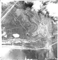
  3. Digital Image - 2017.010p.0016

    Aerial photo of Clute area, 1960. Looking northeast, the image shows Main Street, Reck's grocery store, a gas station, lumber yard, trailer houses, cars, and a cement truck.

    Record Type: Photo

    2017.010p.0016 (resized)
  4. Digital Image - 2017.010p.0018

    Surfside swing bridge, 1954

    Record Type: Photo

    2017.010p.0018 (resized)
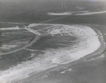
  5. Print, Photographic - 1987.010p.0001

    Photograph, Black and white print of Aerial view of mouth of Brazos River and vicinity. Credit: U.S. Coast and Geodetic Survey and U.S. Coast Guard Prominent features: - Brazos River - Brazos River jetties - Brazosport turning basin - Bryan Cut - Bryan Mound - Dow Barge Canal - East Union Bayou - Freeport - Intracoastal Waterway - Mud Pit - Old Brazos River - Old Reservoir - Gulf of Mexico - Railroads - Staufer turning basin ...

    Record Type: Photo

    aerial view of the Brazos and vicinity
  6. Print, Photographic - 2002.028p.0003

    Courthouse Square Angleton, Texas Medium: Color Photograph October, 2000 Minolta Maxxim 70-210 Telephoto Lens aerial view

    Record Type: Photo

    Courthouse Square
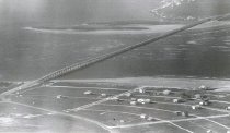
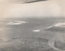
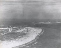
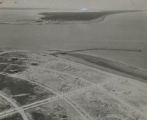
  7. Print, Photographic - 2006.021p.0002

    Aerial photo of San Luis Pass and bridge with land in foreground

    Record Type: Photo

    Aerial photo San Luis Bridge
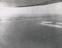
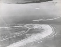
  8. Print, Photographic - 2006.021p.0003

    Aerial photo of San Luis Pass and bridge with water in foreground

    Record Type: Photo

    Aerial photo San Luis Pass
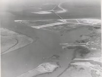
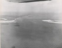
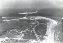
  9. Print, Photographic - 2006.021p.0007

    Aerial photo of San Luis Pass and Intercoastal Canal

    Record Type: Photo

    San Luis Pass & Canal
  10. Print, Photographic - 2006.021p.0008

    Aerial photo of San Luis Pass and bridge

    Record Type: Photo

    San Luis Pass and Bridge
  11. Print, Photographic - 2006.021p.0009

    Aerial photo of San Luis Pass and bridge

    Record Type: Photo

    San Luis Pass and Bridge
  12. Print, Photographic - 2006.021p.0010

    Aerial photo of San Luis Pass and bridge

    Record Type: Photo

    San Luis Pass and Bridge
  13. Print, Photographic - 2006.021p.0011

    Aerial photo of San Luis Pass and bridge

    Record Type: Photo

    Aerial photo of Pass & Bridge
  14. Print, Photographic - 2006.021p.0012

    Aerial photo of San Luis Pass area

    Record Type: Photo

    Aerial view of San Luis Pass
  15. Print, Photographic - 2006.021p.0013

    Aerial photo of San Luis Pass area

    Record Type: Photo

    Aerial photo of San Luis Pass
  16. Print, Photographic - 2006.021p.0015

    Aerial photo of San Luis Pass bridge

    Record Type: Photo

    Aerial view of San Luis Bridge
  17. Print, Photographic - 2006.021p.0016

    Aerial photo of San Luis Pass bridge

    Record Type: Photo

    Aerial view of San Luis Bridge
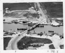
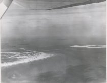
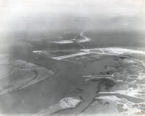
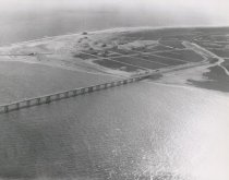
  18. Print, Photographic - 2006.021p.0017

    Aerial photo of the San Luis Pass bridge and pier

    Record Type: Photo

    San Luis Pass and Pier
  19. Print, Photographic - 2006.021p.0018

    Aerial photo of San Luis Pass, 1967

    Record Type: Photo

    San Luis Pass, 1967
  20. Print, Photographic - 2006.021p.0019

    Aerial photo of San Luis Pass bridge

    Record Type: Photo

    aerial of San Luis Pass Bridge

Thank You!

Confirmation Message Here....