Skip to content

Person Record

Metadata

Related Records

  1. Map - 1988.070c.0039

    Map - Drainage District No. 5

    Record Type: Archive

    1988.070c.0039  Title Block
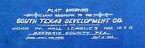
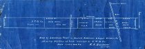
  2. Map - 1988.070c.0109

    Map - South Texas Development Company subdivisions in J. W. Hall Leagues 10 and 11

    Record Type: Archive

    1988.070c.070c  Title Block
  3. Map - 1988.070c.0113

    Map - Sanderson Tract in Andrew Robinson Leauge

    Record Type: Archive

    Map - Sanderson Tract in Andrew Robinson Leauge
  4. Map - 1988.070c.0138

    Map - Drainage District No. 5

    Record Type: Archive

    1988.070c.0037.0138  Title Block
  5. Map - 2009.024c.0027

    Map - Otey USGS quadrangle - Title Services Inc. Plat Map

    Record Type: Archive

    2009.024c.0027 North Half
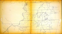
  6. Map - 2009.024c.0030

    Map - Rosharon USGS quadrangle - Title Services Inc. Plat Map

    Record Type: Archive

    2009.024c.0030 North Half

Thank You!

Confirmation Message Here....