
Archive Record
Images
Metadata
Object Name |
Map |
Catalog Number |
1988.070c.0208 |
Title |
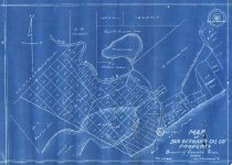
Map - San Bernard Oil Co. Property at mouth of San Bernard River |
Search Terms |
Alsberry Grant Bryan Heights Bryan Mound Butler Survey Cedar Lakes Ducroz Cemetery First Lake Gulf of Mexico Hooven Survey International & Great Northern Railroad Gulf Intracoastal Waterway McClure Survey McNeel tract Murrey Survey Murrie Survey Oil Well Parker Williams Survey Pelican Lake San Bernard National Wildlife Refuge San Bernard Oil Company San Bernard River Second Lake (now Cedar Lakes) South Texas Development Co. |
Scope & Content |
Map Blueprint ----------------------------------------------------------------------------------------- Map of San Bernard Oil Co.'s Property Brazoria County, Texas 1" = 800 varas Feb 29, 1912 J. Lee Chambers, Civil Engineer ----------------------------------------------------------------------------------------- North arrow: yes North direction: top of map Compass bearings: no Scale: 1" = 800 varas Scale unit: vara Prominent Features: - Bryan Heights (shown schematically, not to scale) - Alsberry 1.5 league Grant - First Lake (now Cedar Lakes) - George W. McNeel tract - Gulf of Mexico - Oil Well - Parker Williams Survey - Paul M. Hooven Survey - Pelican Lake - R. McClure Survey - Rebecca Murrey (Murrie) Survey - San Bernard River - Second Lake (now Cedar Lakes) - W. H. Butler Survey Property owners and leaseholders: - Alsberry - Ballard, A.A. - Butler, W.H. - Caldwell, J.F. - Ducroz - Fuller, F. - International and Great Northern Railroad - Johnston - Martin, W. - Masterson, T.G. - McClure, R. - McNeel, C.P. - McNeel, G.W. - McNeel, P.D. - Murrey (Murrie, Murry), Rebecca (Rebeca) - Parker - South Texas Development Co. - Westall, A.E. - Williams |
Subjects |
Alsberry Grant Bryan Heights Bryan Mound Butler Survey Cedar Lakes Ducroz Cemetery First Lake Gulf of Mexico Hooven Survey International and Great Northern Railroad Intracoastal Waterway McClure Survey McNeel tract Murrey Survey Murrie Survey Oil Well Parker Williams Survey Pelican Lake San Bernard National Wildlife Refuge San Bernard Oil Company San Bernard River Second Lake (now Cedar Lakes) South Texas Development Co. |
People |
Alsberry Ballard, A.A. Bass, Nan Butler, W.H. Caldwell, J.F. Chambers, J. Lee Ducroz Fuller, F. Johnston Martin, W. Masterson, Thomas G. McClure, R. McNeel, C.P. McNeel, George W. McNeel, Pleasant D. Murrie, Rebecca Murry, Rebeca Parker Westall, A.E. Williams |
Date |
02/29/1912 |
Dates of Creation |
02/29/1912 |
Extent of Description |
Paper: 14" wide x 13" high Image: 12.5" wide x 9.5" high |
Collection |
Nan Bass |
Accession number |
1988.070c |
Other number |
1988-70-208 |
Source |
Nan Bass |
Credit line |
Nan Bass |
Lexicon category |
8: Communication Artifact |
Catalog type |
Map |
Condition |
Fair |
Imagefile |
008\1988.070c.0208.JPG |
Number of images |
2 |
Relation |
Show Related Records... |