
Archive Record
Images


Metadata
Object Name |
Map |
Catalog Number |
1988.070c.0023 |
Title |
Map - Blueprint of 1988.070c.0183 |
Search Terms |
See 1988.070c.0183 |
Scope & Content |
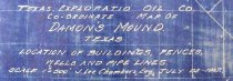
Map Cyanotype blueprint on paper with colored pencil overwrite Blueprint of 1988.070c.0183 ------------------------------------------------------------------------------- Texas Exploration Oil Co. Coordinate Map Damon's Mound Texas Locations of Buildings Fences Wells and Pipe Lines. Scale 1" = 500" J. Lee Chambers, Eng July 25, 1917 ------------------------------------------------------------------------------- North arrow: no North direction: toward top of map clockwise 45 degrees Compass bearings: no Scale: not shown. Scale: 1" = 500 feet (based on a comparison with 1988.070c.0254) Scale unit: feet For further details see 1988.070c.0183 |
Subjects |
See 1988.070c.0183 |
People |
Bass, Nan Chambers, J. Lee |
Date |
07/25/1917 |
Dates of Creation |
07/25/1917 |
Extent of Description |
Paper: 35.5" wide x 39.5" high Image: 34" wide x 37.5" high |
Collection |
Nan Bass |
Accession number |
1988.070c |
Other number |
1988-70-23 |
Source |
Nan Bass |
Credit line |
Nan Bass |
Lexicon category |
8: Communication Artifact |
Catalog type |
Map |
Condition |
Fair |
Imagefile |
007\1988.070c.0023-1.jpg |
Number of images |
4 |
Relation |
Show Related Records... |