
Archive Record
Images
Metadata
Object Name |
Map |
Catalog Number |
1988.070c.0142 |
Title |
Map - Ink study for 1988.070c.0196 |
Search Terms |
County Road 409 CR 409 FM 524 McCormack League McGrew Cemetery Old Main Street Sweeny City of Sweeny Homestead Wilson E.N. Wilson Tract |
Scope & Content |
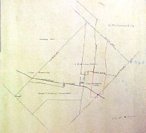
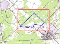
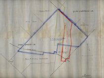
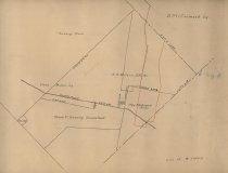
Map Ink on drafting paper with pencil overwrite. No title block Ink study for 1988.070c.0196 E. N. Wilson 555-acre tract in the Charles Breen League, now in the City of Sweeny. The approximate location of the historic center of the City of Sweeny is indicated by notation "City of Sweeny." Includes land now known as McGrew Cemetery. Rear of map contains a portion of what was apparently a larger map of an unknown location. North arrow: no North direction: top of map Compass bearings: yes Scale: 1" = 300 varas Scale unit: vara Prominent features: - County Road (now FM524 and Old Main Street) - McCormack League - McGrew Tract - Reese P. Sweeny Homestead - Wilson Tract Property owners and leaseholders: - McGrew, Mrs. - Sweeny, Reese P. - Wilson E.N. |
Subjects |
County Road 409 CR 409 FM 524 McCormack League McGrew Cemetery Old Main Street Sweeny City of Sweeny Homestead Wilson E.N. Wilson Tract |
People |
Bass, Nan McGrew, Mrs. Sweeny, Rees P. Wilson, Erwin N. |
Extent of Description |
Paper: 17" wide x 15" high Image: 15" wide x 13" high |
Collection |
Nan Bass |
Accession number |
1988.070c |
Other number |
1988-70-142 |
Source |
Nan Bass |
Credit line |
Nan Bass |
Lexicon category |
8: Communication Artifact |
Catalog type |
Map |
Condition |
Fair |
Imagefile |
007\1988.070c.0142-1.JPG |
Number of images |
4 |
Relation |
Show Related Records... |