
Archive Record
Images

Metadata
Object Name |
Map |
Catalog Number |
2008.010c.0014 |
Title |
Map - Hydrographic Survey No. 6305 |
Search Terms |
Brazos River Coast of Texas Gulf of Mexico Hydrography Shoreline U. S. Coast & Geodetic Survey |
Scope & Content |
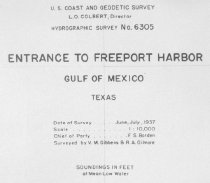
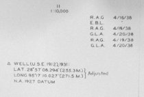
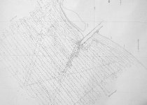
Map Hydrographic Survey No. 6305 Part of Texas Coast Survey Diazotype Whiteprint ------------------------------------------------------------------------------------------- U. S. Coast & Geodetic Survey L. G. Colbert, Director Hydrographic Survey No. 6305 Entrance to Freeport Harbor Gulf of Mexico, Texas Date of Survey .... June, July 1937 Scale .................... 1:10000 Chief of Party ..... F. S. Borden Surveyed by V.M. Gibbens & R. A. Gilmore Soundings in Feet of Mean Low Water ------------------------------------------------------------------------------------------- North arrow: no North direction: Parallel to meridians Compass bearings: no Scale: 1:10,000 Scale unit: ratio |
Subjects |
Brazos River Coast of Texas Gulf of Mexico Hydrography Shoreline U. S. Coast & Geodetic Survey |
People |
Colbert, L.G. |
Date |
07/01/1937 |
Dates of Creation |
07/01/1937 |
Year Range from |
1937 |
Year Range to |
1937 |
Extent of Description |
Paper: 42" wide x 59" high Image: 32" wide x 53" high |
Collection |
U. S. Coast Survey - Coast of Texas |
Accession number |
2008.010c |
Source |
BCHM |
Credit line |
BCHM |
Lexicon category |
8: Communication Artifact |
Catalog date |
2008-04-22 |
Catalog type |
Archive |
Imagefile |
021\2008.010c.0014-1.jpg |
Number of images |
4 |