
Archive Record
Images

Metadata
Object Name |
Map |
Catalog Number |
1986.003c.0004 |
Title |
Map - Old Brazoria 1828-1958 |
Search Terms |
Old Brazoria map, 1828-1958 survey plat Brazoria County, Texas |
Scope & Content |
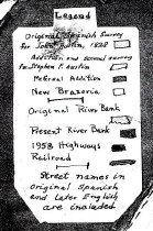
Map - Old Brazoria 1828-1958 Hand drawn with ink and watercolor on paper with cardboard backup and pasted-on inset. Includes hand-lettered legend on separate paper pasted onto map. North arrow: no North direction: top of map N45W Compass bearings: no Scale: Not to scale Prominent features: - Brazos River - Historic shorelines - Brazos River - Present (1958) shorelines - China Street Bridge (1912) (labeled "First Bridge"; no long extant) - FM521 - SH332/FM521Bridge (1939) (labeled "Present Highway Bridge") - UPRR bridge (labeled "Railroad Bridge") Streets named on map - Austin Street [Calle Alamo] - Burnet Street (now Burnett Street) - Calle Limon (now High St.) - Calle Naranja (now Pleasant St.) - Calle Sous (no longer extant or never existed) - Calle Vina (now Brooks St.) - Camp Street - Cedar Street - Cherry Street - China Street - Elm Street [Calle Olmo[ (no longer extant or never existed) - Liberty Street - Main Street [Calle del Rio] (now Old Main St.) - Marion Street - Market Street [Calle Principia] - Milam Street - Oak Street (now Red Oak St.) - Peach Street (no longer extant) - Pearl Street [Calle Morena] - SH36 - Travis Street - Velasco Street |
Subjects |
Old Brazoria map, 1828-1958 survey plat Brazoria County, Texas |
People |
Boddie, W.W. |
Date |
1940s |
Extent of Description |
17.5" wide x 23.5" high |
Collection |
W.W. Boddie |
Accession number |
1986.003c |
Other number |
1986-03-04 |
Source |
W.W. Boddie |
Credit line |
W.W. Boddie |
Lexicon category |
8: Communication Artifact |
Catalog date |
2011-05-31 |
Catalog type |
Map |
Condition |
Fair |
Imagefile |
024\1986.003c.0004.jpg |
Number of images |
2 |
Received date |
1/21/86 |