
Archive Record
Images
Metadata
Object Name |
Map |
Catalog Number |
2013.003c.0037 |
Title |
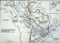
Map - Dow Diversion Channel |
Search Terms |
Brazos River Brazos River Levee Dow Chemical Company Dow diversion channel East Levee Gulf of Macaco L.J.-C. Main Channel Old River North Levee Phillips Petroleum Pumping station South Levee Tidal Gate Velasco Wave barrier |
Scope & Content |
Map - Dow Diversion Channel Xerographic copy of a digital printout of a larger map Printed black on white with red pen overwrite North arrow: yes North direction: top of map Compass bearings: no Scale: Graphic(scales at approx 1" = 2000') Scale Unit: Feet Prominent features: - Dow diversion channel from SH332 to pumping station - Dow Plants A and B. - Specific sites along route highlighted in red overwrite ------------------------- TRANSCRIPT ------------------------- Item numbers are from 1979 bond program Summary dated 6 November 1979 Richwood improvements not shown ----------------------------------------------------------------------- |
Dates of Creation |
11/29/1860 |
Year Range from |
1979 |
Year Range to |
1990 |
Extent of Description |
23" wide x 34" high |
Collection |
Transfer from Library Collection |
Accession number |
2013.003c |
Source |
Transfer from Library Files |
Credit line |
Found in Collection |
Lexicon category |
8: Communication Artifact |
Catalog date |
2013-10-09 |
Catalog type |
Archive |
Imagefile |
034\2013003c0037.JPG |
Number of images |
1 |
Received date |
01/14/2013 |