
Archive Record
Images
Metadata
Object Name |
Map |
Catalog Number |
2014.010c.0003 |
Title |
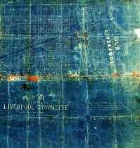
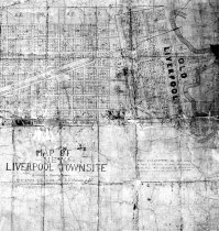
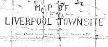
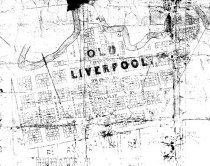
Map - Map of New Liverpool Townsite - 1908 (partial) |
Search Terms |
Ann Street Calhoun Street Chocolate Bayou Commerce Street Exchange Street Ferguson Street Front Street Hampton Street Heath Street Johnson Street Liverpool New Liverpool Townsite (surveyed 1908) Old Liverpool (surveyed 1837) Pearle Street Phillip Street Preston Street St. John Street St. Louis, Brownsville and Mexico Railway Union Pacific Railroad Washington Street Wharton Street |
Scope & Content |
Map - Map of New Liverpool Townsite - 1908 (partial) Cyanotype Blueprint Appears to be the eastern half of a larger map (Blocks 1-14 not shown) North arrow: no North direction: top of map Compass bearings: no Scale: Unknown (not noted) Scale Unit: Unknown This map consists of two surveys: - "Old Liverpool" (surveyed 1837) - "New Liverpool Townsite" (surveyed 1908) Prominent Features: -Chocolate Bayou -Unidentified railroad (formerly St. Louis, Brownsville, & Mexico Railway; now UPRR). Outside of Old Liverpool - 3rd St. through 11th Street - Ave A through Ave G - Blocks 1-51 Inside Old Liverpool - Ann Street - Blocks 15-82 - Calhoun Street - Commerce Street - Exchange Street - Ferguson Street - Front Street - Hampton Street - Heath Street - Johnson Street - Pearle Street - Phillip Street - Preston Street - St. John Street - Washington Street - Wharton Street |
People |
Atkinson, E. S., Jr., C.E. (Civil Engineer) Hunt, W.H. Roden, Robby |
Date |
1837 and 1908 |
Dates of Creation |
1837 (Old Liverpool) 1908 (New Liverpool Townsite) |
Year Range from |
1827 |
Year Range to |
1908 |
Extent of Description |
21'"wide x 13" high |
Collection |
Robby Roden Collection |
Accession number |
2014.010c |
Source |
Robby Roden |
Credit line |
Robby Roden |
Lexicon category |
8: Communication Artifact |
Catalog date |
0014-03-05 |
Catalog type |
Archive |
Imagefile |
035\2014010c0003.JPG |
Number of images |
4 |
Received date |
04/15/2014 |