
Archive Record
Images
Metadata
Object Name |
Map |
Catalog Number |
2008.010c.0011 |
Title |
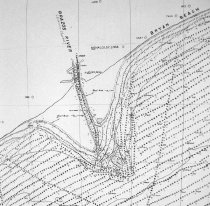
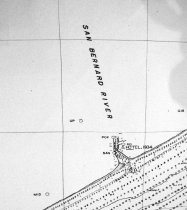
Map - Coast of Texas and Brazos River mouth |
Search Terms |
Brazos River Coast of Texas Gulf of Mexico Hydrography Point Bolivar Shoreline U. S. Coast & Geodetic Survey |
Scope & Content |
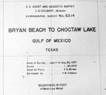
Map Coast of Texas and Brazos River mouth Part of U.S. Coast Survey Positive Photostat ------------------------------------------------------------------------------------------- U.S. Coast and Geodetic Survey L. O. Colbert Director Hydrographic Survey No. 6314 Bryan Beach to Choctaw Lake Gulf of Mexico, Texas Date of Survey: July 11 to Aug. 28, 1937 Scale: 1:20000 Chief of Party: F. S. Borden Surveyed by: V. M. Gibbens Soundings in Feet at Mean Low Water ------------------------------------------------------------------------------------------- North arrow: yes North direction: top of map Compass bearings: yes Scale: 1:20,000 Scale unit: feet |
Subjects |
Brazos River Coast of Texas Gulf of Mexico Hydrography Point Bolivar Shoreline U. S. Coast & Geodetic Survey |
People |
Borden, F.S. Colbert, L.O. Gibbens, V.M. |
Date |
08/28/1937 |
Dates of Creation |
08/28/1937 |
Year Range from |
1937 |
Year Range to |
1937 |
Extent of Description |
Paper: 65" wide x 42" high Image: 62" wide x 41" high |
Collection |
U. S. Coast & Geodetic Survey of Texas Coast |
Accession number |
2008.010c |
Source |
BCHM |
Credit line |
BCHM |
Lexicon category |
8: Communication Artifact |
Catalog date |
2008-04-08 |
Catalog type |
Archive |
Imagefile |
021\2008.010c.0011-1.jpg |
Number of images |
3 |