
Archive Record
Images
Metadata
Object Name |
Map |
Catalog Number |
1988.070c.0145 |
Title |
Map - Sweeny-Black's Ferry Road |
Search Terms |
Black's Ferry FM1459 Missouri Pacific Railroad San Bernard River SH 35 St. Louis, Brownsville and Mexico Railway Sweeny Sweeny Black's Ferry Road |
Scope & Content |
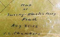
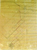
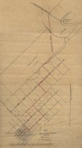
Map Black ink on onionskin paper with red pencil overwrite ------------------------------------------------------------------------------------------- Map of Sweeny-Black's Ferry Road. Aug 27 1912. J. L. Chambers ------------------------------------------------------------------------------------------- North arrow: yes North direction: top of map Compass bearings: no Scale: non specified Scale unit: unknown Prominent Features - Black's Ferry (no longer extant) - Proposed road to be named "Sweeny-Black's Ferry Road" (now FM1459) - Road to Chance Prairie (now FM1459 north of SH35) - San Bernard River (not labeled) - St. Louis, Brownsville, and Mexico Railroad (now UPRR) - Sweeny townsite - Unnamed tributaries of San Bernard River Property owners and leaseholders: - Sweeny, W.L. - Wilson, Carrie |
Subjects |
Black's Ferry FM1459 Missouri Pacific Railroad San Bernard River SH 35 St. Louis, Brownsville, and Mexico Railroad Sweeny Sweeny Black's Ferry Road UPRR |
People |
Bass, Nan Chambers, J. Lee Sweeny, W.L. Wilson, Carrie |
Date |
08/27/1912 |
Dates of Creation |
08/27/1912 |
Extent of Description |
Paper: 16.5" wide x 22" high Image: 15" wide x 21" high |
Collection |
Nan Bass |
Accession number |
1988.070c |
Other number |
1988-70-145 |
Source |
Nan Bass |
Credit line |
Nan Bass |
Lexicon category |
8: Communication Artifact |
Catalog type |
Map |
Condition |
Fair |
Imagefile |
007\1988.070c.0145-1.JPG |
Number of images |
3 |