
Archive Record
Images
Metadata
Object Name |
Map |
Catalog Number |
2013.003c.0007 |
Title |
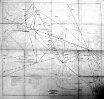
Map / USCGS Map 589 / Ship Channel Triangulation Diagram |
Search Terms |
Alexander Island Baytown Baytown Tunnel (no longer extant) Buffalo Bayou Burnett Bay Carpenter Bayou Carpenter Bayou Crystal Lake Houston Ship Channel Houston Ship Channel Lost Lake Lynchburg Mitchell Bay Old River San Jacinto Battlefield Monument San Jacinto Bay San Jacinto River Scott Bay Triangulation Diagram U.S. Coast And Geodetic Survey USCGS Wooster |
Scope & Content |
Map / USCGS Map 589 / Ship Channel Triangulation Diagram Houston Ship Channel, Alexander Island to Carpenter Bayou Printed in blue ink on paper with black overprint showing triangulation stations North arrow: Yes North arrow direction: top of map Compass bearings: no Scale: Linear (scales at 1" = 0.170213 nautical mile) Scale Unit: Nautical miles and yards ------ TRANSCRIPTION OF ORIGINAL TITLE BLOCK ----- United States -- Gulf Coast Texas Houston Ship Channel Alexander Island to Carpenter Bayou Soundings in feet at mean low water Published at Washington, D.C. Mar. 1937 (First Edition 1933) U.S. Coast And Geodetic Survey R.F.A. Studds, Director Houston Ship Channel, Alexander Island to Carpenter Bayou) U.S. C. & G.S. 589 ------------------------------------------------------------------------------------- ------ TRANSCRIPTION OF OVERPRINT TITLE BLOCK ----- Triangulation Diagram Showing Triangulation Stations Adjusted on North American 1927 Datum April, 1951 (Not for Navigation Purposes) ------------------------------------------------------------------------------------- Prominent features - Baytown - Baytown Tunnel (no longer extant) - Lynchburg - San Jacinto Battlefield Monument - Wooster Waterways: - Buffalo Bayou - Burnett Bay - Carpenter Bayou - Crystal Lake - Houston Ship Channel - Lost Lake - Mitchell Bay - Old River - San Jacinto Bay - San Jacinto River - Scott Bay |
People |
Studds, R.F.A. (Director, USCGS, 1955) |
Date |
April 1951 |
Dates of Creation |
April 1951 |
Extent of Description |
27.5" wide x 26" high |
Collection |
Transfer from Library Files |
Accession number |
2013.003c |
Other number |
USCGS Chart 589 |
Source |
Transfer from Library Files |
Credit line |
Found in Collection |
Lexicon category |
8: Communication Artifact |
Catalog date |
2013-03-05 |
Catalog type |
Archive |
Imagefile |
030\2013003c0007-1.JPG |
Number of images |
1 |
Received date |
01/14/2013 |