
Archive Record
Images
Metadata
Object Name |
Map |
Catalog Number |
1988.070c.0207 |
Title |
Map - Hawes Tract out of S.F.Austin 7 1/3 league |
Search Terms |
Austin 7 1/3 league Black's Ferry Blacks Ferry Brazoria townsite Brazos River Brignace Tract Columbia CR347 Hawes Tract Haws Tract Peach Point Stephen F. Austin 7 1/3 League Stern & Stern Weisiger Land Co. White Tract |
Scope & Content |
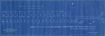
Map Blueprint ---------------------------------------------------------------------------------------- Subdivision of that part of the Stephen F. Austin 7 1/3 league grant known as "The Hawes Tract" adjoining the Town of Brazoria, Texas. From actual surveys on the ground made by me in May and June 1898. C. E Packard, Civil Engineer and Surveyor, Houston, Tex. Scale 1" = 1000' ---------------------------------------------------------------------------------------- North arrow: yes North direction: top of map Compass bearings: yes Scale: 1" = 1000 feet Scale unit: feet Prominent Features: - Black's Ferry Road (now approximately SH36) - Brazos River (topographically incorrect) - Cleared Road (now CR347) - "Road to Columbia" (topographically impossible) - Town Tract (Brazoria) |
Subjects |
Austin 7 1/3 league Black's Ferry Blacks Ferry Brazoria townsite Brazos River Brignace Tract Columbia CR347 Hawes Tract Haws Tract Peach Point Stephen F. Austin 7 1/3 League Stern & Stern Weisiger Land Co. White Tract |
People |
Packard, C.E. |
Date |
05/01/1898 |
Dates of Creation |
05/01/1898 |
Extent of Description |
Paper: 29.2" wide x 10.3" high Image: 28.5" wide x 9.3" high |
Collection |
Nan Bass |
Accession number |
1988.070c |
Other number |
1988-70-207 |
Source |
Nan Bass |
Credit line |
Nan Bass |
Lexicon category |
8: Communication Artifact |
Catalog type |
Map |
Condition |
Fair |
Imagefile |
008\1988.070c.0207.JPG |
Number of images |
1 |
Relation |
Show Related Records... |